• CONTACT US if you have any problems registering for the forums.

Wiradjuri, Kamilaroi and Wailwan Country (Australia)

Galgano

100+ Posts
Hi Pauline,
After the last 10 months of isolation, and the dissapointment of not making it to Spain and England mid year, Cheryl and I are embarking on a 16 day road trip through the north of New South Wales. Following horendous bushfires and drought, the rains came, and much of this country has seen the regeneration of the wetlands of the interior.

If you thinlk this miight be of interest ... despite not being Europe ... I'll start posting as we go.
 
We managed to get away by 8.00 am with a plan for the day that involved a one and a half hour drive to Leura near the top of the Blue Mountains for breakfast. Then we would drive the 2 hours to Rylstone for lunch with friends that had moved out that way 14 years ago. We hadn’t seen them in 10 years. After lunch we would explore the town and then drive for an hour to Gulgong.
Sunday morning traffic in the time of Covid is pretty good and we made good time on the motorway for the first half hour to the foothills of the Blue Mountains. Traffic was surprisingly heavy going up the mountains, but not slow. The most notable thing about the mountains at this time of the year, is that the white wattle is in full flower and the Blue Mountains are more like the Bronze Red Mountains. When the entire range is covered in gum trees sprouting their new leaves, they are a combination of deep red and a bronze tinge. Unfortunately, I couldn’t find anywhere to stop and photograph them. Hopefully the Warrumbungles will be similar when we arrive there on Wednesday.
Our favorite café at Lerura was temporarily closed, so we settled on an old style 1920’s café across the road. Of course they serve “Savoury Mince”. For those too young to appreciate, mince with some Worcestershire Sauce, and diced carrot, peas and corn kernels. For you Americans, perhaps a variation of “Sloppy Joe”???
On to Lithgow near the bottom of the Great Dividing Range on the western side and then turn off and head north, flanking the range. We may have returned to Sydney via this route in the past, however it always looks different going in the opposite direction. Fortunately I googled the country later in the day and discovered that we had taken the Bylong Valley Way. Back in 2012, it was named as one of the twelve best drives in Australia … up there with the Great Ocean Road.
It began with country recovering from bush fires with the black trunks stark against the bare earth on the flanks of hills and mountains, then progressed to spectacular country set against the mountains and massive sandstone cliffs and mounds. This is country that slows you down. We weren’t in a hurry and took a leisurely drive on toward Rylstone.
At this point our son Kent phoned us to tell us that if we were going to go to Rylestone, we had to go to De Beaurepairs winery. He and Lyle had visited around a month ago and loved it. OMG, this turned out to be the best advice ever.
We drove out to the winery and discovered it involved a 3km drive on a dirt and rocky road over hill and dale through the vineyards. On arriving, we realized that a tasting was impractical in 25 minutes, so drove back to Rylestone for lunch with Judy and Jimmy.
Jimmy is an Irishman, now 30 years in Australia and Cheryl worked with Judy in rehabilitation services 20 years ago. Of all places to meet, it was one of their favorites … serving Yum Cha and bookings essential. Really, in the middle of the bush you have to book and people drive for an hour to go there. That good. A great reunion over, we decided to explore the towns historic buildings. “Where are my notes?” “You didn’t give them to me.” “Yes I did,” “No you didn’t or I would have them.” “O.K., lets go back to the winery”
This was the most spectacular vinyard/winery find of all time. De Beaurepair make Burgundy style wines. I adore Mersault, and at $A120.00 a bottle have only had it twice. I’ve been in search of the Australian equivalent for 5 years, and I do mean consistently trying to find one. The search is over. Bought 3 bottles at $A60.00, and will return when they have been consumed.

The De Beaurepairs spent 10 years searching for land that had as close to identical "terroir" to Burgundy. This is in the midwest and yet is "cold climate" rather than "cool climate" wine country. It has the right amount of limestone and bordered on three side by a river to which they have water rights. Ideal for producing Burgundy style wines. They recently installed Laser bird deterent equipment and the grapes saved and converted to wine, paid for the very expensive technology in just two years.

Why produce Burgundy style wines instead of Australian? Because at half the price, why import from Burgundy. Why drink Burgundy style wines? Because they go with food better than almost any other.

Finally, at around 4.30 we took a circuitous route … all due to the inefficiency of our satnav, on to Gulgong. Around about then, Cheryl found that she did infact have my notes about Rylestone.
 

Attachments

  • IMG_3016.JPG
    IMG_3016.JPG
    168.3 KB · Views: 18
  • IMG_3019.JPG
    IMG_3019.JPG
    118.1 KB · Views: 23
  • IMG_3024.JPG
    IMG_3024.JPG
    106.8 KB · Views: 20
  • IMG_3026.JPG
    IMG_3026.JPG
    117.2 KB · Views: 18
  • IMG_3031 (1).jpg
    IMG_3031 (1).jpg
    95.7 KB · Views: 20
  • IMG_3033.JPG
    IMG_3033.JPG
    122.7 KB · Views: 18
  • IMG_9039A.jpg
    IMG_9039A.jpg
    177.5 KB · Views: 21
Very interesting. While I have close to zero interest in wines, I just had to google the De Beaurepair vineyard, and went to their website. I was very impressed by the meticulous thought and work they put into the establishment of their vineyard, simply amazing. I wonder - do you know if they also irrigate their vines, or is there enough rainfall in that area? It's also a bit strange that they do not want or need to be certified organic, but it's clear that they are very centered on promoting life in the soil, and place huge emphasis on the connection between quality and soil components.

It might be depressing, but I also wouldn't mind seeing a pic or two of the burnt-out forests, if you have some - we saw them on TV while they were burning, but I haven't seen the aftermath.
 
Hi Joe
Yes, they do irrigate. Drip irrigation. The told me that they would't even consider establishing a vinyard without reliable access to water. They have water rights to the river which adjoins three sides of their land. They have had two droughts in the last ten years and this last one ended just as the river was running dry. Very precarious country as the majority of rainfall is on the eastern side of the Great Dividing Range not this side.

I'll look for some photos of the post-bushfire country. The damage is unprecedented and more so to the wildlife. Much of the forests will regenertate in time, however native animal populations much more slowly.
 
This has been quite a spectacular day. Kent and Lyle had told us about visiting “The Drip” and “Hands on the Rock” when they visited Mudgee a month ago. We decided that we would take the back roads from Gulgong via both sites on our way north to Coonabarrabran.

It was a stress-free day until now. I took around 250 photographs and videos and now I have to decide on just ten to post as a summary of our day.

We stayed in the old Price of Wales Hotel in Gulgong. Built in 1872, we thought the main front bar would have to be the original bar. Probably the only remaining feature is the floor. With a corrugated iron “roof’ over the bar itself and TV screens tuned to every sporting station and TAB, it’s a shame they haven’t thought to restore it to something like the original. A keyboard painted on the wide step between the billiard room and the bar was …… sad.

We had one of the new rooms built as old style motel room at the rear carpark and it was comfortable and quiet.

Every time we have visited Gulgong, we have been struck by the fact that it is probably one of New South Wales’s most authentic old towns. Almost all of the original buildings have their original facades. The streets are narrow and always lined with cars and it is a narrow passage down every street. Imagine our surprise when at 7:30 we went for a walk and there was hardly a car in sight. As Ches will tell everyone, I hate cars and people in y photographs of historic buildings.

Oh, B.T.W., remember those notes about a walking tour of Rylestone that I couldn’t find yesterday. The ones I hadn’t given Ches. She found them on our way to Mudgee later in the day.

Bruce Elder published his first book in 1971. It was a high school drama text called “Exit Pursued By a Bear” and published by John Wiley and Sons and I had just began working for them. Among other books he wrote, was “Blood on the Wattle” in 1988. Possibly the first to address the massacre on indigenous Australians. These days, he maintains a website about hundreds of Australian country towns and he writes the following about Gulgong. I couldn’t write a better description.

“To fully experience Gulgong it is necessary to wander along Mayne Street and Herbert Street and soak up the historic ambience of this remarkable goldmining town which has over 130 heritage buildings. Part of Gulgong's unique appeal lies in the fact that it began before surveyors could turn it into just another country town with a boring street grid system. Consequently, the main roads in town, originally tracks for horses and bullocks, wind and meander through a picturesque and well-preserved settlement of single-storey weatherboard, iron, stone and brick buildings with old-fashioned iron-lace verandas, tiny wooden cottages, horse troughs and hitching rails. The result is a gold mining town which once was home to 20,000 and is now held in the aspic of history.”

Around 10:00 am we set off for “The Drip”. The Goulburn River runs through a gorge an hours drive north from Gulgong. It’s a sandstone gorge and “The Drip” is a section where the sandstone has layers of clay high up in an overhanging cliff that curves over the river and permanently drips water. It is a 3.5km round walk, at times up and down stone staircases and at other times climbing over rocks. The advice is that it is a 1.5 hour round walk. We took 2 hours; not because we are slow walkers or that I stop to take a hundred or so photographs, which I don’t deny I do, but because we also stopped often, to enjoy the experience. The tranquility of running water and the sounds of birds.

Most other 50 or so walkers passed us and we would have been the last to return to the carpark. Just 3km further up the road was “Hands on the Rock”.

We turned off the highway and down a dirt track. I made the comment “If all the dirt roads we have to traverse on this trip are like this, it’s going to easy.” 10 seconds later we came up behind a very smart “Commodore” that was struggling to avoid bottoming on the ridges and furrows that was now the dirt road. There were sections where the washouts were 1/3 of a meter deep and ½ meter wide. We both gave up and backed up to park on the side of the track. It was only two or three hundred meters to the carpark and then another 500m climb up a very rugged track to the overhanging cliffs where there are dozens of hand stencils. We observed that the hands were all very small. Placing a hand on the rock, women and children had spat a mixture of red ochre and gum/water etc. leaving their hand print.

I suggested that they all must have been made by women or children. Only now, on researching further have I found that this was a birthing site. Men were forbidden.

We finished the day with a 2 hour drive along the Warumbungle Way to Coonabarrabran.
 

Attachments

  • IMG_3040.JPG
    IMG_3040.JPG
    65.9 KB · Views: 16
  • IMG_3042.JPG
    IMG_3042.JPG
    90.5 KB · Views: 14
  • IMG_3055.JPG
    IMG_3055.JPG
    103.4 KB · Views: 17
  • IMG_3068.JPG
    IMG_3068.JPG
    112.7 KB · Views: 19
  • IMG_3074.JPG
    IMG_3074.JPG
    66.8 KB · Views: 28
  • IMG_3078.JPG
    IMG_3078.JPG
    94.2 KB · Views: 20
  • IMG_3080.JPG
    IMG_3080.JPG
    95.5 KB · Views: 18
  • IMG_3089.JPG
    IMG_3089.JPG
    94.3 KB · Views: 15
The Drip
 

Attachments

  • IMG_3111.JPG
    IMG_3111.JPG
    154.9 KB · Views: 32
  • IMG_3123.JPG
    IMG_3123.JPG
    168.4 KB · Views: 17
  • IMG_3128.JPG
    IMG_3128.JPG
    168.8 KB · Views: 16
  • IMG_3129.JPG
    IMG_3129.JPG
    105.5 KB · Views: 15
  • IMG_3135.JPG
    IMG_3135.JPG
    129.1 KB · Views: 19
  • IMG_3166.JPG
    IMG_3166.JPG
    180.1 KB · Views: 15
  • IMG_3179.JPG
    IMG_3179.JPG
    136.2 KB · Views: 17
  • IMG_3204.JPG
    IMG_3204.JPG
    128.2 KB · Views: 17
Hands on the Rock
 

Attachments

  • IMG_3262.JPG
    IMG_3262.JPG
    102.9 KB · Views: 18
  • IMG_3269.JPG
    IMG_3269.JPG
    104.1 KB · Views: 19
  • IMG_3275.JPG
    IMG_3275.JPG
    89.1 KB · Views: 17
  • IMG_3277.JPG
    IMG_3277.JPG
    88.5 KB · Views: 20
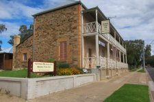
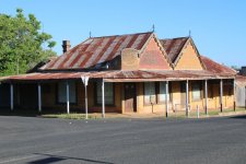
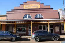
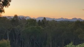
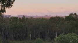
We are staying at Bloodwood Ridge, an Airbnb owned by Sam, who is an arborist. Our apartment is at the back of the house with a deck that looks out on the Warrambungles. I couldn’t imagine a better view of them at dawn and sunset. Just stunning. He promotes his business as having “a Billion star rating”

The four-hour driving circuit around the Warrambungles, to take them in from all angles, was deleted from the five options I had planned for the two days we are based here in Coonabarabran. No way will we spend more time in the car than walking through the bush.

Nevertheless, Ches wasn’t up to my 4-hour walks, so we decided on the Whitegum lookout, the Wambelong Nature walking track and Burbie Canyon walking track. These are both listed as being easy walks. There are a number of walking tracks that involve camping out overnight and taking in the massive sky show, however we decided some time ago, that those days are behind us. Actually, they are behind Ches. They were never my days. I slept on a banana lounge with a mattress, in the back of my panel van, the last time I camped out.

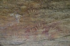
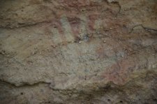
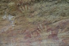
The Warrambungles is big sky country. It’s has such a clean and clear atmosphere that the Siding Springs Observatory is located on the highest peak. August is when the Wiradjuri to the south and the Kamilaroi here, used to conduct many of their male initiation ceremonies. The Emu is one of their creation spirits and their story tells of the Emu living in the sky as part of the Milky Way and coming to earth where he became flightless. The Emu in the Milky Way is not formed by the stars but is actually the dark space in the middle. In August, it is most visible and that is when the Emu lays its eggs.

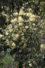
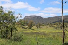
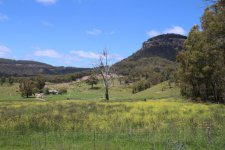
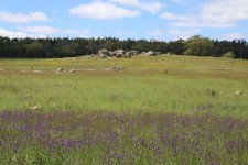
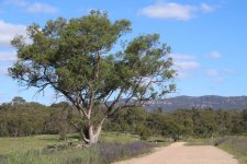
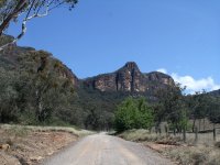
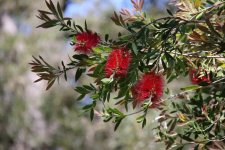
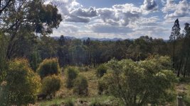
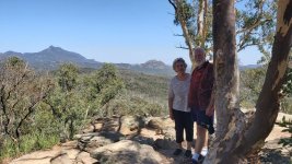
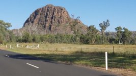
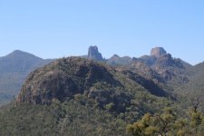
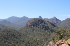
Whitegum lookout is on the way into the park and at the top of the first high mountain looking down and across the valley. From the left you can see: Balougery Spire, Breadknife, Bress Peak, Cathedral Rock and Split Rock. Just stunning, and we sat and took in the tranquility … and the bird song. Birdsong and wildflowers were the theme for the day. Everywhere we went there were carpets of wildflowers and bird song of great variety … and the buzzing of bees … and flies.

Every time we returned to the car, a dozen flies would join us for the drive to the next site. Faster than flying I guess.

We must have spent more than half an hour, just sitting and taking in the view as the sun rose high in the sky behind us. What a view.

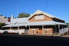
We decided to visit the “Visitors Centre” to check on just how difficult the “Frans Horizon” is. Grade 3, moderate to steep. 3.6km, 2 hours return. The great thing about this walk is, that we get to see the Breadknife from side on. It is the plan for tomorrow, however Ches felt a need to check out just how “moderate to STEEP, it is” By the time we arrived at the Centre, it was closed for lunch. How lucky were we? Really lucky as it eventuated.

Just along the road from the Centre is the “Wambelong Nature track”. We passed a couple we had met at Whitegum, as they returned. I imagine that like us, they arrived at the carpark to find they were the only car, and that the usual signage and map board had been removed. Also like us, they had no idea where to find the track. We decided to go on to the Burbie Canyon walk and return later to the Information Centre and the Wambelong walk.

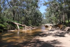
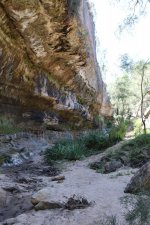
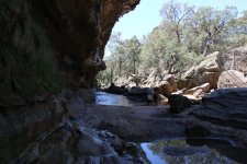
The Burbie Canyon walk was disappointing in comparison to yesterdays “The Drip” walk. There was barely any water in the river (creek) and the canyon section wasn’t much more than a couple of hundred meters long. It made up for it with masses of wildflowers, thousands of bees and myriad bird songs. Not a wallaby or kangaroo to be see, however lots of poo along the track … so they are there. Not an emu or koala either. It was the middle of the day however, with the temperature getting up to 27c (81F), and they were all probably taking shelter.

It was listed as 2km 40-minute walk. It took us well over an hour.

We drove back to the Information Centre and were advised that the Franz Horizon walk which is recorded as being “moderate to steep, 3.6km and 2 hours return” has around 1,000 steps and quite steep. Cheryl’s hips began to protest at the thought. O.K., best in the early morning, so we will start at 8.00am. Ches may not complete the journey but stop half way. We’ll see what the morrow brings we thought. Think again after what happened next.

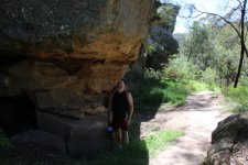
We returned to the “Wambelong Nature track”. The guide had said that we should just follow the track along the river from the carpark and that it would involve crossing the river twice. Just a short 1.3km walk taking around 45 min. I’ve since read a dozen or so travelers reports on this walk, and they all agree … a leisurely stroll. I think they all took a short cut at the end, because a leisurely stroll, turned into a major climb and scramble over a massive rock dome and a descent that would be very difficult in wet weather.

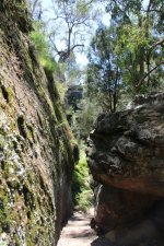
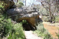
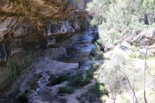
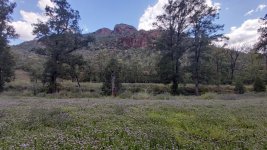
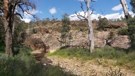
The track began with a mowed path through the middle of a field of wildflowers. With the river out of sight to our right and a massive rock dome to our left, we suddenly entered a canyon with steep cliffs on both sides … yup, that’s what a canyon is. Beautifully scenic. At the river (creek at this time of the year), it was a precarious crossing stepping from stone to stone. Every meter or so, I stopped to offer Ches my hand for balance. She made it across dry. I decided that a photograph up the canyon, taken from the middle of the creek, would look particularly good. May balance since the 2007 stroke has never fully returned. I completed the walk with a soaked right foot.

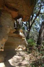
It was a lovely walk along the river through fields of wildflowers and back across the creek on high concrete pylons this time. Serenaded by birds and bees all the way. Here we came across the far side of the rock dome. A sign explained that it is a good example of columnar jointing. Basically the rock is a mass of vertical columns all joined together which contrasts with most other rock formations that are horizontal in layers. It’s due to the lava cooling inward from the top.

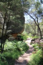
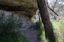
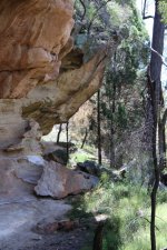
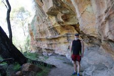
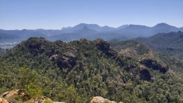
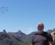
At this point all we could see was the rock to our left, a field of flowers ahead and the road we had driven in on to our right. I think 99.9% of people then follow the road around to the picnic/car park. I chose to hug the cliff and found a track with steps going up onto the rock. Several hundred steps and ten minutes later, the track ended and all I could see was fluorescent yellow track markers nailed to the rock face. We clambered up to the top of the rock. From here we had distant views of the Whitegum lookout and the Breadknife. As I filmed, Ches suggested I look behind me. There, towering over us was Split Rock.

We continued over the top of the rock to the canyon where we had started. From here it was a fairly steep decent on very smooth rock to the bottom. Over an hour, and an experience that caused alarm for Ches as she contemplated tomorrows proposed walk that involves 1,000 steps on a 3.6km, 2 hour track.

While at Whitegum lookout, people had told us about “Donna the Astronomer”. She runs Milroy Observatory, with nightly small group experiences. Star Gazing. We had sent a text requesting a booking for either tonight or tomorrow night. Phone service in the park is intermittent, so it wasn’t till we exited the park that we received a reply confirming it for Wednesday night.

That settled it; an early start tomorrow for the Frans Horizon walk, an afternoon at home, out for dinner and then star gazing.
 

Attachments

  • IMG_3212.JPG
    IMG_3212.JPG
    107.6 KB · Views: 15
  • IMG_3221.JPG
    IMG_3221.JPG
    130.4 KB · Views: 13
  • IMG_3262.JPG
    IMG_3262.JPG
    102.9 KB · Views: 15
  • IMG_3269.JPG
    IMG_3269.JPG
    104.1 KB · Views: 16
  • IMG_3273.JPG
    IMG_3273.JPG
    140 KB · Views: 16
  • IMG_3275.JPG
    IMG_3275.JPG
    89.1 KB · Views: 17
  • IMG_3278.JPG
    IMG_3278.JPG
    106.7 KB · Views: 17
  • IMG_3283.JPG
    IMG_3283.JPG
    120.4 KB · Views: 14
  • IMG_3305.JPG
    IMG_3305.JPG
    128 KB · Views: 16
  • 20201109_165940.jpg
    20201109_165940.jpg
    115.3 KB · Views: 19
  • 20201109_193110.jpg
    20201109_193110.jpg
    47.4 KB · Views: 16
  • 20201110_060343.jpg
    20201110_060343.jpg
    63 KB · Views: 17
  • 20201110_112138.jpg
    20201110_112138.jpg
    117.2 KB · Views: 20
  • 20201110_142824.jpg
    20201110_142824.jpg
    128.4 KB · Views: 17
  • 20201110_143629.jpg
    20201110_143629.jpg
    142.4 KB · Views: 6
Having decided to go to an astronomy site tonight, we settled on an early 8.00 am start on the Fans Horizon walk while it is still relatively cool, and then the afternoon on the deck, looking out on the Warrumbungles (this could mean .. a nap).

30 million years ago, the Warrumbungles was a volcano with a diameter of 50k. For 4 million years it erupted through a number of vents. Over the last 26 million years, it has been worn down and the various “tors” and rock formations such as “The Breadnkife’ , that I’ve been photographing, are the lava that was in those vents.

There might have been around ten vehicles in the carpark when we arrived. This is the starting point for around 5 different walks, so we had no idea how many might be going in our direction, however it was unlikely to be any more than 20 people. As it eventuated, we started out with another couple just ahead of us, another couple arrived at the summit just behind us and we passed 3 people on their way up as we were returning. Not exactly Pitt or Bourke Sts.

It’s recorded as 3.6km return and as taking 2 hours. There are 1,000 stair steps involved, and most are at a gradient of 50 or more degrees. Steep, narrow and rocky. We took a little less than 3 hours with a 20 minute stay at the top.

All the way to the top, we were serenaded by bird song. As with yesterday’s walks, there was lots of variations in their calls. It occurred to me that there was no evidence of lorikeets or any type of parrot. There are the occasional pair of Sulphur Crested White Cockatoos, but no colourful birds. On reflection, and with no verification from Google or any other more reliable authority, it’s possibly because this isn’t flowering tree country. Lorikeets and parrots require flowering gums and bottlebrushes etc to provide nectar and seeds. The birds of the Warrumbungles are insect eaters, so dull in colour and hard to see in the scrub and forest.

Again, there was ample evidence of Wallabies, with poo on the track pretty well the length of the trail. I’m going to apply some “Poetic License” here and post some photographs that aren’t mine. They were taken by other walkers last year. So, we heard or saw evidence of these birds and animals, but didn’t actually see them.

There was still significant evidence of the bushfires that raged here 7 years ago. The dead trunks stand twice as high as the new trees that are growing up to replace them. At this rate it’s going to be 14 year for the forest to be back to where it used to be on this mountain. Cheryl then reminded me that we had seen a number of man-made nesting boxes in the dead trees around the rock mound we had climbed yesterday afternoon. They are to replace all the hollows and holes in trees where birds and possums nest and reproduce. Small hollows can take 120-150 years to form. Their narrow entrances are suitable for small animals, such as the Eastern Pygmy Possum. Medium hollows can take over 200 years to form and provide nests for larger possums or birds.

Following the last east coast bushfires, there were people up and down the coast building nesting boxes to provide shelter for the few animals and birds that survived. As Cheryl reminded me, If we continue to log old growth forests, we are destroying the little surviving habitat that is left.

It was quite a slog to the summit, with dense scrub and trees right to the top. We sat and drank in the tranquility … bird song and the wind in the trees, for around 20 minutes. The breeze helped moderate what was becoming a humid and hot day. It reached 28c (83F). We also drank more water, before the descent. At this point, I realized I had been once again giving one creature no credit at all. Beautiful white butterflys. White on the top with black wing tips and yellow and black on the underside. There were hundreds of them among the wildflowers yesterday, along with thousands of bees, which I hope were native bees rather than European.

After a very active three days, we decided to take the afternoon off.
 

Attachments

  • 20201111_081647.jpg
    20201111_081647.jpg
    64.7 KB · Views: 7
  • 20201111_103254.jpg
    20201111_103254.jpg
    102.9 KB · Views: 8
  • 20201111_103531a.jpg
    20201111_103531a.jpg
    86.4 KB · Views: 7
  • IMG_3522.JPG
    IMG_3522.JPG
    81.2 KB · Views: 22
  • IMG_3533.JPG
    IMG_3533.JPG
    84.7 KB · Views: 6
Very interesting. While I have close to zero interest in wines, I just had to google the De Beaurepair vineyard, and went to their website. I was very impressed by the meticulous thought and work they put into the establishment of their vineyard, simply amazing. I wonder - do you know if they also irrigate their vines, or is there enough rainfall in that area? It's also a bit strange that they do not want or need to be certified organic, but it's clear that they are very centered on promoting life in the soil, and place huge emphasis on the connection between quality and soil components.

It might be depressing, but I also wouldn't mind seeing a pic or two of the burnt-out forests, if you have some - we saw them on TV while they were burning, but I haven't seen the aftermath.
Unfortunately, the best images are those filmed from aircraft flying over at sufficient height to capture vast tracts of the mountains. The best I can do are these photos. Just imagind tens of thousands of acres like this.

I just discovered that this show will screen in Australia on December 1st. I hope you can open and watch the trailer. A word of warning ... it brought tears to my eyes.
https://www.if.com.au/wild-australia-after-the-fires-trailer/
 

Attachments

  • Bushfire-CRC_fires-near-Kinglake_IMG_5846.jpg
    Bushfire-CRC_fires-near-Kinglake_IMG_5846.jpg
    119.9 KB · Views: 10
  • 51220309_303.jpg
    51220309_303.jpg
    69.1 KB · Views: 11
  • 2033a0d1-57dc-4326-abda-e736d78f8ff8.jpg
    2033a0d1-57dc-4326-abda-e736d78f8ff8.jpg
    139.3 KB · Views: 8
Last edited:
Thanks for the pics and link concerning the aftermath of the horrible fires. Indeed, very very sad. Hard to grasp the scale of the damage from where I sit, but the aerial shots and the trailer make it very clear how devastating this was.
And thanks for the pics of your beautiful outings in the wild, you have an amazing countryside over there...
 

How to Find Information

Search using the search button in the upper right. Search all forums or current forum by keyword or member. Advanced search gives you more options.

Filter forum threads using the filter pulldown above the threads. Filter by prefix, member, date. Or click on a thread title prefix to see all threads with that prefix.

Sponsors

Booking.com Hotels in Europe
AutoEurope.com Car Rentals

Recommended Guides, Apps and Books

52 Things to See and Do in Basilicata by Valerie Fortney
Italian Food & Life Rules by Ann Reavis
Italian Food Decoder App by Dana Facaros, Michael Pauls
French Food Decoder App by Dana Facaros, Michael Pauls
She Left No Note, Lake Iseo Italy Mystery 1 by J L Crellina

Share this page

Back
Top