
The Amalfi Coast is a south facing peninsula in the Campania region, south of Naples. It is lined with mountains that drop steeply to the coast. Towns spread up the mountain sides from the water. The main towns from west to east are Positano, Praiano, Amalfi, and Ravello. There are more towns east of Amalfi but these are not as popular with tourists from abroad. A busy and somewhat narrow road, the infamous Amalfi Coast Road, winds along the coast dramatically going high up at some points and along the water at others. You can drive to the different towns or take a bus or ferry to them. Ravello sits high above the sea, well off the coast road, and can be reached by car or bus.
The larger town of Sorrento is on the north western side of the peninsula, with the Sorrento Peninsula below it, and is connected to the Amalfi Coast by road and bus. The island of Capri is nearby and connected by ferry.
Any of the main Amalfi Coast towns make a good base for exploring this area and doing some hiking. Hikers can walk trails high above the towns, from Positano to Amalfi and beyond. The Path of the Gods (Il Sentiero degli Dei in Italian) is the most popular trail and for good reasons - it is easy to walk and has tremendous views. There are a lot of hiking trails in these mountains, many almost as interesting as the Path of the Gods, easier to get to, and less crowded. I will write about these in another article. But first, the Path of the Gods, which deserves its great reputation.
The Path of the Gods (Il Sentiero degli Dei)
The Path of the Gods, a hiking trail along the tops of the mountains on the Amalfi coast, starts in Agerola, a village near Bomerano above Amalfi, and ends in Nocelle, a village above Positano. Walking the trail going west from Agerola gives you an easy downhill walk. There are magnificent views of the Amalfi Coast and the island of Capri from the trail.
Duration: 2 - 3 hours one way (Agerola to Nocelle)
Length: 7.8km/4.8mi
Descent: 205m. The trail starts at 635 meters at Agerola, 600 meters at Colle la Serra and goes down to 430 meters at Nocelle at the end. There is some up and down in spots, but it is mostly a very gentle downhill.
Guidebook: You do not need a guidebook or hiking app to do this hike. I give you all the information you need here and the trail is clearly marked (the markers are red and white stripes). If you would like to read more, refer to the Cicerone Guide - Walking on the Amalfi Coast - Walk 18 - Sentiero degli Dei.
Website: Il Sentiero degli Dei (positano.com)
Parts of this trail are exposed and close to a steep drop off, but overall it is an easy trail. Wear good walking shoes as the trail can be rocky and a bit rough in places. If walking in hot weather, do the walk early in the morning during the cooler hours and bring lots of water. There is a tap to fill your water bottle at Colle la Serra. If walking in cooler weather, be aware that clouds may cover the trail so be flexible about which day you walk the trail. You will see if the trail is clear looking up from the coast towns.
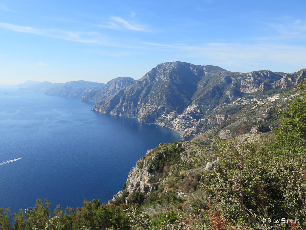
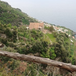
View from the Path of the Gods to Positano and the Amalfi Coast.
Description of the Hike: The Path of the Gods trail starts in the main piazza in Bomerano di Agerola. Get there by bus from Amalfi (read more about this below). There is a shop and a cafe in the village where you can get sandwiches. The trail from Bomerano goes through terraces with grazing goats and sheep and then enters a more open area where you start to get views of the coast. Soon you reach the Colle la Serra (a large rocky mountain top) where the path splits. Keep left on the lower path.
The trail is extraordinary. You are 600 meters above the sea with views down to Praiano and Positano, and along the coast as far as Capri. Parts of the path are narrow and with a very steep drop off, so it made me a bit nervous. It is not really flat because you are going up and down, sometimes climbing up steep stone parts, but it is not a difficult walk. It is a popular hike, so you will see other people on the trail. People hike in both directions, but most go the way I am recommending, from Agerola to Nocelle. It is not over crowded and it is fun seeing the other hikers.
At the end of the trail in Nocelle there is a small restaurant right on the trail as it comes into the village. There are no other restaurants or shops in Nocelle, but there are several down the road in Montepertuso. From Nocelle you can take the bus back to Positano or walk down (read more about this below).
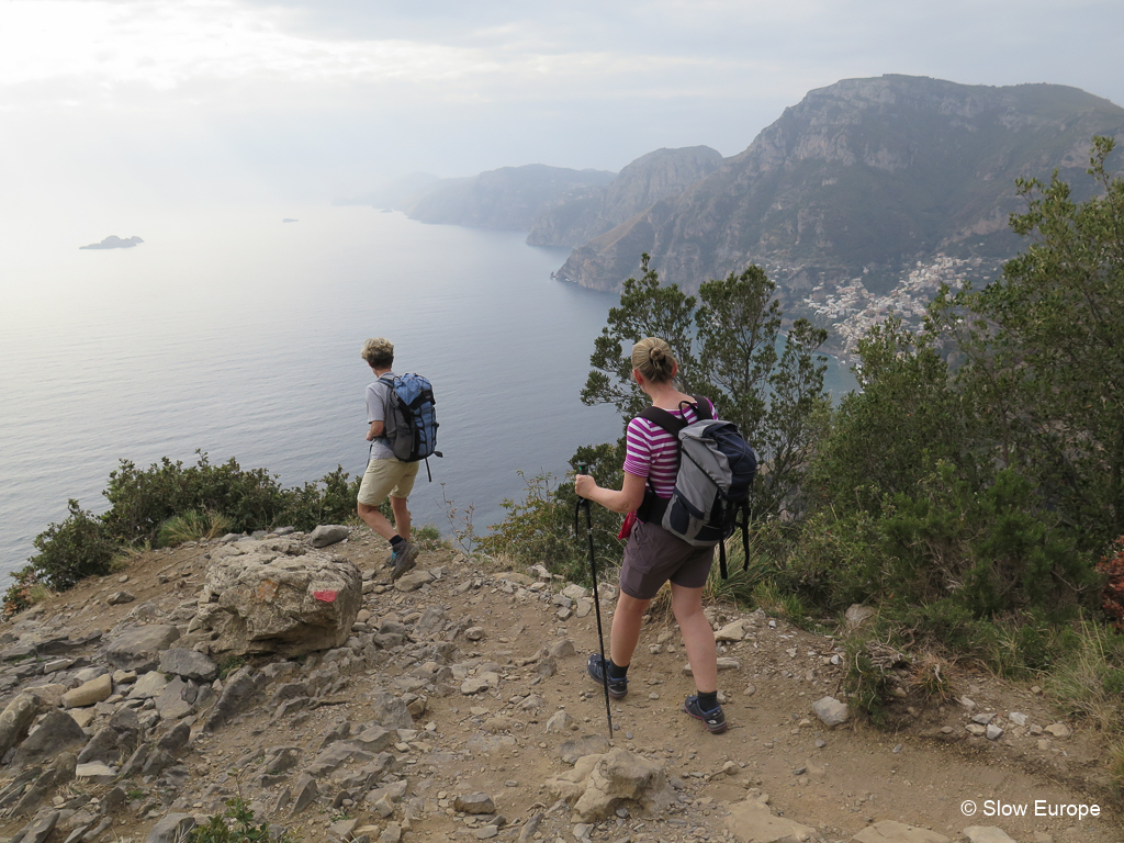
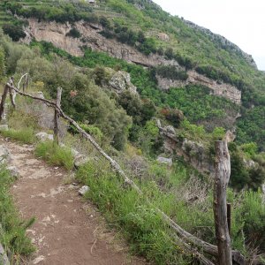
In spots the path is close to the edge.
Transportation to the Start in Agerola: The difficulty for this hike is the arrangements to get to the start of the trail. While the start and the end are only a few miles apart on the trail, they are many miles apart by car or bus. The start of the trail in Agerola is much further up in the mountains than the end of the trail in Nocelle. This means that it takes a long time to get to the start of the hike, especially if you are staying in Positano or Praiano.
The road to Agerola starts west of Amalfi, half way between Amalfi and Conca dei Marini, and winds up the mountain on switchbacks. It is a good road but can be slow going because of the many tight turns. From Positano it is over 1.5 hours by bus, or an hour by car service.
Bus: The bus to Agerola leaves from Amalfi, so if you are staying in Positano, you take the SITA bus to Amalfi and then change for Agerola. The bus from Positano to Amalfi runs a few times an hour. The bus from Amalfi to Agerola runs less than once an hour, so check the schedules.
For example:
Positano (Chiesa Nuova) 9:20 - Amalfi 10:10
Amalfi 10:15 - Agerola (Bomerano) 10:55
The bus to Agerola does not run frequently. You can arrive at 8:45, 10:55 or 12:20, or later (2021 schedule).
Car Service: This is the faster option (1 hour from Positano) but is more expensive. Expect to pay over €100 for a group up to four from Positano. Some car services offer shuttles to Agerola for about €25 per person.
Transportation from the End in Nocelle: From Nocelle you can take the local bus back to Positano. From the end of the trail follow the signs to the parking lot (parcheggio). The bus stop is there. Be aware that it is a small bus and you might not make it on during high season. (We’ve always made it on the bus.)
If you don’t want to take the bus, you can walk down stairs from Nocelle (1500 steps). This brings you to the coast road east of Positano and from there you can walk to Positano. It is better to walk to Montepertuso (trail part way and then along the road which is not busy) where you can walk down to a more central location in Positano (1700 steps). The version of this hike in the Cicerone Guide details this last part of the hike, walking down from Montepertuso. There are signs pointing to the different routes down to Positano.
Bus Schedules
Amalfi Coast Bus (SITA): The SITA buses go from Sorrento to Positano and along the coast road to Amalfi. They do not go into the towns. Positano and Praiano have local buses that go through the town. At Amalfi there is a bus station where you can change for SITA buses to continue along the coast to Salerno, to go up to Ravello and to go up to Agerola (for the Path of the Gods). Purchase tickets in the local bars or tobacco (tabaccherie) shops. Sometimes they have someone selling tickets at the main SITA stops.
The SITA buses run about twice an hour from Positano. The coast road in Positano runs along the top of the town so you may have a bit of a walk to the bus stop or you can take the local bus. There are two main stops, one at each end of town. The western stop is at Bar Internationale where the town road into Positano starts. The other stop is at the eastern edge of Positano where the town road comes out. This bus can be very crowded. You may end up standing for the long and winding road to Amalfi. When I am on the SITA buses I use google maps on my phone to follow the route and to know when we are coming to my stop.
Amalfi Coast Bus Schedules (positano.com): SITA Bus schedules.
Local Buses from Positano: The coast road goes along the top of Positano, with much of the town below it. A smaller local road goes into the town (one way starting from the western edge of town) and comes out on the other side of town where it meets the coast road. In Praiano most of the town is above the coast road. Praiano also has a one way local road that takes you up through the town. Local buses in Positano do a loop around Positano, or go up to Nocelle (where the Path of the Gods ends), or go to Praiano and up through the town. These buses run frequently. Purchase tickets in the local bars or tobacco (tabaccherie) shops.
Mobility Amalfi Coast: Local bus schedules. Interno Positano is the bus that loops around the town. You can find more information on their Facebook page.
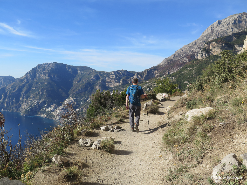
Beautiful views of the Amalfi Coast from the Path of the Gods.
Alternatives Ways to Get on the Path of the Gods
There are two other ways to approach this hike to avoid the long bus ride to Agerola – hike from the end at Nocelle and go out and back or climb up to the trail from Praiano. I have done both of these options and have outlined them below.
My advice? If you are staying in Positano or Praiano, and enjoy a good climb, start from Praiano. Climb up to the trail and then walk to Nocelle. I would rather do the climb than deal with the bus to Agerola. If you are staying in Amalfi, take the bus to Agerola and do the whole hike.
Alternative 1: Walk the trail twice (out and back). To avoid the long bus ride to Agerola, you can instead start and end at Nocelle above Positano – walk the trail out and back. This doubles your walking time but avoids the 1.5 hour bus ride. You get a longer hike instead of a long bus ride. This is a good option if you are staying in Positano. The downside is that on your way out there will be people coming towards you since you are going “against traffic”. If you do not want to do the whole trail, walk out to the marker and water tap above Praiano and turn around there. This is the best part of the trail and probably takes 2 hours each way.
Bus: A local bus runs hourly from Positano to Nocelle.
Drive: Drive and park at Nocelle (limited parking). It is a 15min drive from Bar Internazionale on the coast road in Positano. Take the coast road in the direction of Sorrento and turn right on SS163 west of Positano.
Alternative 2: Climb up to the trail from Praiano. Praiano sits almost directly below Agerola, the official start of the hike. Instead of taking the bus to Agerola, walk up the mountain from Praiano to the Path of the Gods (500m climb), then walk the Path of the Gods to Nocelle where you can get a bus to Positano. This option works best if you are staying in Positano or Praiano. Local small buses run regularly to Praiano from Positano.
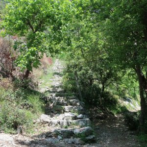
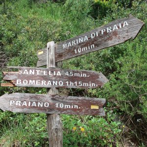
There are three trails from Praiano to the Path of the Gods. The best route is to walk straight up to the Colle la Serra. From the Guercio bus stop on the coast road in Praiano, walk back towards Positano for a few feet, to a fountain in Piazzetta Gagliano. Take pedestrian Via Russo up hill. Follow the signs for Path of the Gods or Colle la Serra and keep going up until you see the staircase at the top of the town. This takes 1 – 2 hours to climb straight up the mountain, 500m ascent if you start from the coast road, but less if you take the local bus to the top of the town at the San Luca church and start from there. You join the Path of the Gods at the water tap, about ¼ of the way along the trail from the start at Agerola. Turn left to walk to Nocelle. It takes about two hours to reach Nocelle, four hours in total for this hike. Take the bus back from Nocelle.
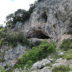
There are two other trails that go up to the Path of the Gods. On the western edge of Praiano, follow the signs to Convento San Domenico. You start out walking along charming narrow lanes of Praiano, then reach a pretty wooded area where you take the stairs up. This is an easy hike up to San Domenico, 50 minutes - 800 steps, but is steep and rocky from there to get to the Path of the Gods. Not recommended (but I did manage it). On the eastern edge of Praiano, follow the signs to Grotto de Santa Barbara or Bomerano. This is a lovely hike but is a bit long. It takes you almost to the start of the Path of the Gods in Agerola, so you end up walking the whole Path of the Gods.
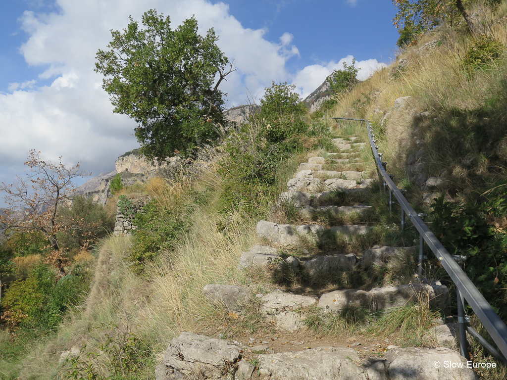
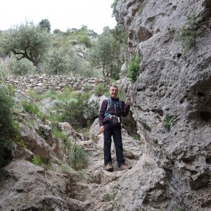
Climbing up from Praiano to Colle la Serra to reach the Path of the Gods.
Google Map
View on Google Maps.View: https://www.google.com/maps/d/embed?mid=1SfkYM7okY0CqGBeJz9cmDty81gHqDLTQ&hl=en
More Photos
My Description of Walking the Path of the Gods in October 2017
In October 2017 I hiked the Path of the Gods with Steve and our friends Bryan and Valerie. We were staying in Positano and got a car service (Positano Taxis) to take us to Bomerano. The journey was 60 minutes - 30 minutes on the winding coast road, then 30 minutes on hairpin turns going up the mountain. Bomerano sits above Praiano, but it is a long drive to get there. The car service cost €100 for the four of us and was well worth it. In the summer they run a shuttle bus.
It was interesting seeing the Agerola valley - a large plain high above the Amalfi Coast with several villages and surrounded by higher mountains. It looks like there is good hiking up there and would be an interesting place to stay. The main road continues north from this valley in the direction of Naples.
We started the walk at 11:20am and finished at 2:40pm (3hr20min), with a nice long stop for lunch on the trail. It was a holiday, All Saints Day, and there were a lot of people walking. We took our time because there is a lot of up and down and the path is rocky. It was sunny and warm, 65F but it felt warmer. The views were incredible. For the first 30 minutes from Bomerano you don't see down the coast. You are walking above terraced gardens. Once you get out of that first canyon you have views all down the coast to Capri. The trail is narrow in spots with a steep drop off. Other parts are easier to walk. Towards the end you walk in woods.
We were in good time for the 2:50 bus from Nocelle but it was packed with people and we had to stand for the 30 minute very winding ride down. We were all a bit seasick after. We were pretty proud of ourselves doing the hike! Highly recommended – this is the way to see the Amalfi Coast!
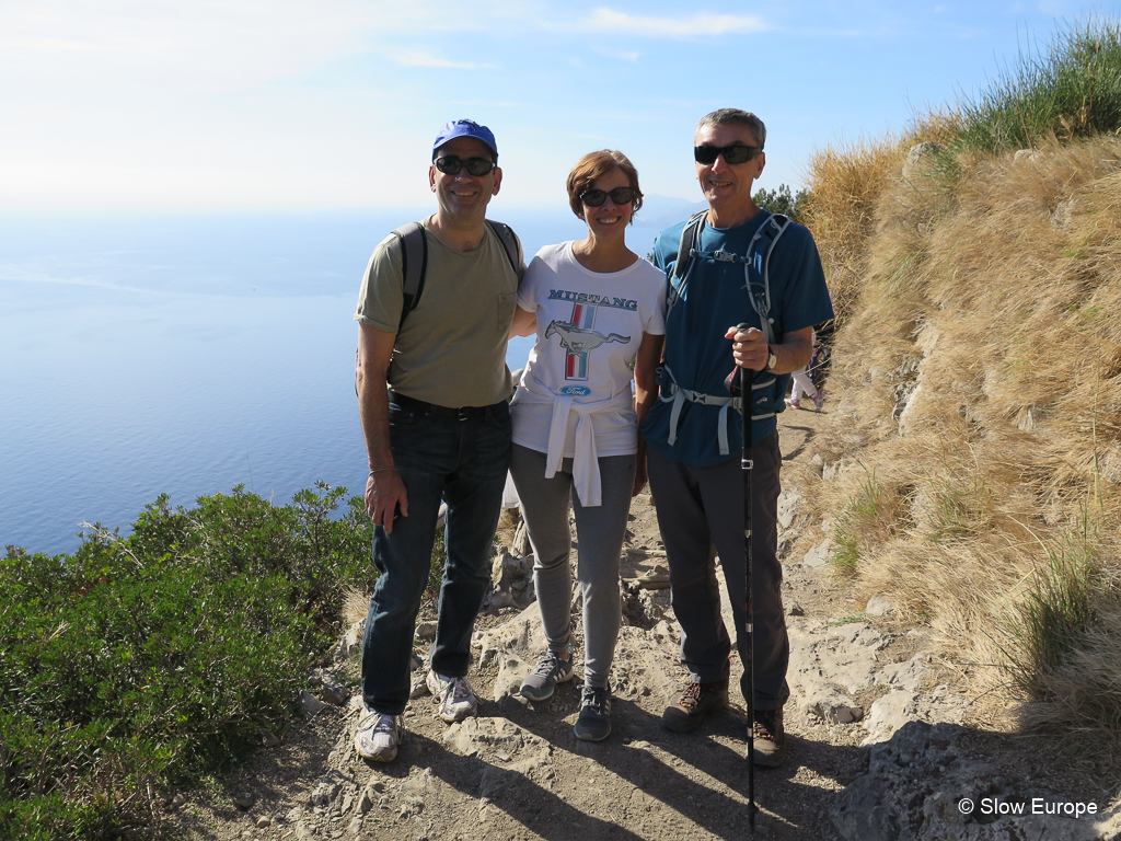
Our happy group - Bryan, Valerie, Steve, and me behind the camera.
Trip Reports
Read my trip reports from our three recent trips to the Amalfi Coast:
The larger town of Sorrento is on the north western side of the peninsula, with the Sorrento Peninsula below it, and is connected to the Amalfi Coast by road and bus. The island of Capri is nearby and connected by ferry.
Any of the main Amalfi Coast towns make a good base for exploring this area and doing some hiking. Hikers can walk trails high above the towns, from Positano to Amalfi and beyond. The Path of the Gods (Il Sentiero degli Dei in Italian) is the most popular trail and for good reasons - it is easy to walk and has tremendous views. There are a lot of hiking trails in these mountains, many almost as interesting as the Path of the Gods, easier to get to, and less crowded. I will write about these in another article. But first, the Path of the Gods, which deserves its great reputation.
The Path of the Gods (Il Sentiero degli Dei)
The Path of the Gods, a hiking trail along the tops of the mountains on the Amalfi coast, starts in Agerola, a village near Bomerano above Amalfi, and ends in Nocelle, a village above Positano. Walking the trail going west from Agerola gives you an easy downhill walk. There are magnificent views of the Amalfi Coast and the island of Capri from the trail.
Duration: 2 - 3 hours one way (Agerola to Nocelle)
Length: 7.8km/4.8mi
Descent: 205m. The trail starts at 635 meters at Agerola, 600 meters at Colle la Serra and goes down to 430 meters at Nocelle at the end. There is some up and down in spots, but it is mostly a very gentle downhill.
Guidebook: You do not need a guidebook or hiking app to do this hike. I give you all the information you need here and the trail is clearly marked (the markers are red and white stripes). If you would like to read more, refer to the Cicerone Guide - Walking on the Amalfi Coast - Walk 18 - Sentiero degli Dei.
Website: Il Sentiero degli Dei (positano.com)
Parts of this trail are exposed and close to a steep drop off, but overall it is an easy trail. Wear good walking shoes as the trail can be rocky and a bit rough in places. If walking in hot weather, do the walk early in the morning during the cooler hours and bring lots of water. There is a tap to fill your water bottle at Colle la Serra. If walking in cooler weather, be aware that clouds may cover the trail so be flexible about which day you walk the trail. You will see if the trail is clear looking up from the coast towns.
View from the Path of the Gods to Positano and the Amalfi Coast.
Description of the Hike: The Path of the Gods trail starts in the main piazza in Bomerano di Agerola. Get there by bus from Amalfi (read more about this below). There is a shop and a cafe in the village where you can get sandwiches. The trail from Bomerano goes through terraces with grazing goats and sheep and then enters a more open area where you start to get views of the coast. Soon you reach the Colle la Serra (a large rocky mountain top) where the path splits. Keep left on the lower path.
The trail is extraordinary. You are 600 meters above the sea with views down to Praiano and Positano, and along the coast as far as Capri. Parts of the path are narrow and with a very steep drop off, so it made me a bit nervous. It is not really flat because you are going up and down, sometimes climbing up steep stone parts, but it is not a difficult walk. It is a popular hike, so you will see other people on the trail. People hike in both directions, but most go the way I am recommending, from Agerola to Nocelle. It is not over crowded and it is fun seeing the other hikers.
At the end of the trail in Nocelle there is a small restaurant right on the trail as it comes into the village. There are no other restaurants or shops in Nocelle, but there are several down the road in Montepertuso. From Nocelle you can take the bus back to Positano or walk down (read more about this below).
In spots the path is close to the edge.
Transportation to the Start in Agerola: The difficulty for this hike is the arrangements to get to the start of the trail. While the start and the end are only a few miles apart on the trail, they are many miles apart by car or bus. The start of the trail in Agerola is much further up in the mountains than the end of the trail in Nocelle. This means that it takes a long time to get to the start of the hike, especially if you are staying in Positano or Praiano.
The road to Agerola starts west of Amalfi, half way between Amalfi and Conca dei Marini, and winds up the mountain on switchbacks. It is a good road but can be slow going because of the many tight turns. From Positano it is over 1.5 hours by bus, or an hour by car service.
Bus: The bus to Agerola leaves from Amalfi, so if you are staying in Positano, you take the SITA bus to Amalfi and then change for Agerola. The bus from Positano to Amalfi runs a few times an hour. The bus from Amalfi to Agerola runs less than once an hour, so check the schedules.
For example:
Positano (Chiesa Nuova) 9:20 - Amalfi 10:10
Amalfi 10:15 - Agerola (Bomerano) 10:55
The bus to Agerola does not run frequently. You can arrive at 8:45, 10:55 or 12:20, or later (2021 schedule).
Car Service: This is the faster option (1 hour from Positano) but is more expensive. Expect to pay over €100 for a group up to four from Positano. Some car services offer shuttles to Agerola for about €25 per person.
Transportation from the End in Nocelle: From Nocelle you can take the local bus back to Positano. From the end of the trail follow the signs to the parking lot (parcheggio). The bus stop is there. Be aware that it is a small bus and you might not make it on during high season. (We’ve always made it on the bus.)
If you don’t want to take the bus, you can walk down stairs from Nocelle (1500 steps). This brings you to the coast road east of Positano and from there you can walk to Positano. It is better to walk to Montepertuso (trail part way and then along the road which is not busy) where you can walk down to a more central location in Positano (1700 steps). The version of this hike in the Cicerone Guide details this last part of the hike, walking down from Montepertuso. There are signs pointing to the different routes down to Positano.
Bus Schedules
Amalfi Coast Bus (SITA): The SITA buses go from Sorrento to Positano and along the coast road to Amalfi. They do not go into the towns. Positano and Praiano have local buses that go through the town. At Amalfi there is a bus station where you can change for SITA buses to continue along the coast to Salerno, to go up to Ravello and to go up to Agerola (for the Path of the Gods). Purchase tickets in the local bars or tobacco (tabaccherie) shops. Sometimes they have someone selling tickets at the main SITA stops.
The SITA buses run about twice an hour from Positano. The coast road in Positano runs along the top of the town so you may have a bit of a walk to the bus stop or you can take the local bus. There are two main stops, one at each end of town. The western stop is at Bar Internationale where the town road into Positano starts. The other stop is at the eastern edge of Positano where the town road comes out. This bus can be very crowded. You may end up standing for the long and winding road to Amalfi. When I am on the SITA buses I use google maps on my phone to follow the route and to know when we are coming to my stop.
Amalfi Coast Bus Schedules (positano.com): SITA Bus schedules.
Local Buses from Positano: The coast road goes along the top of Positano, with much of the town below it. A smaller local road goes into the town (one way starting from the western edge of town) and comes out on the other side of town where it meets the coast road. In Praiano most of the town is above the coast road. Praiano also has a one way local road that takes you up through the town. Local buses in Positano do a loop around Positano, or go up to Nocelle (where the Path of the Gods ends), or go to Praiano and up through the town. These buses run frequently. Purchase tickets in the local bars or tobacco (tabaccherie) shops.
Mobility Amalfi Coast: Local bus schedules. Interno Positano is the bus that loops around the town. You can find more information on their Facebook page.
Beautiful views of the Amalfi Coast from the Path of the Gods.
Alternatives Ways to Get on the Path of the Gods
There are two other ways to approach this hike to avoid the long bus ride to Agerola – hike from the end at Nocelle and go out and back or climb up to the trail from Praiano. I have done both of these options and have outlined them below.
My advice? If you are staying in Positano or Praiano, and enjoy a good climb, start from Praiano. Climb up to the trail and then walk to Nocelle. I would rather do the climb than deal with the bus to Agerola. If you are staying in Amalfi, take the bus to Agerola and do the whole hike.
Alternative 1: Walk the trail twice (out and back). To avoid the long bus ride to Agerola, you can instead start and end at Nocelle above Positano – walk the trail out and back. This doubles your walking time but avoids the 1.5 hour bus ride. You get a longer hike instead of a long bus ride. This is a good option if you are staying in Positano. The downside is that on your way out there will be people coming towards you since you are going “against traffic”. If you do not want to do the whole trail, walk out to the marker and water tap above Praiano and turn around there. This is the best part of the trail and probably takes 2 hours each way.
Bus: A local bus runs hourly from Positano to Nocelle.
Drive: Drive and park at Nocelle (limited parking). It is a 15min drive from Bar Internazionale on the coast road in Positano. Take the coast road in the direction of Sorrento and turn right on SS163 west of Positano.
Alternative 2: Climb up to the trail from Praiano. Praiano sits almost directly below Agerola, the official start of the hike. Instead of taking the bus to Agerola, walk up the mountain from Praiano to the Path of the Gods (500m climb), then walk the Path of the Gods to Nocelle where you can get a bus to Positano. This option works best if you are staying in Positano or Praiano. Local small buses run regularly to Praiano from Positano.
There are three trails from Praiano to the Path of the Gods. The best route is to walk straight up to the Colle la Serra. From the Guercio bus stop on the coast road in Praiano, walk back towards Positano for a few feet, to a fountain in Piazzetta Gagliano. Take pedestrian Via Russo up hill. Follow the signs for Path of the Gods or Colle la Serra and keep going up until you see the staircase at the top of the town. This takes 1 – 2 hours to climb straight up the mountain, 500m ascent if you start from the coast road, but less if you take the local bus to the top of the town at the San Luca church and start from there. You join the Path of the Gods at the water tap, about ¼ of the way along the trail from the start at Agerola. Turn left to walk to Nocelle. It takes about two hours to reach Nocelle, four hours in total for this hike. Take the bus back from Nocelle.
There are two other trails that go up to the Path of the Gods. On the western edge of Praiano, follow the signs to Convento San Domenico. You start out walking along charming narrow lanes of Praiano, then reach a pretty wooded area where you take the stairs up. This is an easy hike up to San Domenico, 50 minutes - 800 steps, but is steep and rocky from there to get to the Path of the Gods. Not recommended (but I did manage it). On the eastern edge of Praiano, follow the signs to Grotto de Santa Barbara or Bomerano. This is a lovely hike but is a bit long. It takes you almost to the start of the Path of the Gods in Agerola, so you end up walking the whole Path of the Gods.
Climbing up from Praiano to Colle la Serra to reach the Path of the Gods.
Google Map
View on Google Maps.View: https://www.google.com/maps/d/embed?mid=1SfkYM7okY0CqGBeJz9cmDty81gHqDLTQ&hl=en
More Photos


Amalfi Coast, The Path of the Gods
- Pauline
- 44
Hiking along the tops of the mountains on the Amalfi Coast.
My Description of Walking the Path of the Gods in October 2017
In October 2017 I hiked the Path of the Gods with Steve and our friends Bryan and Valerie. We were staying in Positano and got a car service (Positano Taxis) to take us to Bomerano. The journey was 60 minutes - 30 minutes on the winding coast road, then 30 minutes on hairpin turns going up the mountain. Bomerano sits above Praiano, but it is a long drive to get there. The car service cost €100 for the four of us and was well worth it. In the summer they run a shuttle bus.
It was interesting seeing the Agerola valley - a large plain high above the Amalfi Coast with several villages and surrounded by higher mountains. It looks like there is good hiking up there and would be an interesting place to stay. The main road continues north from this valley in the direction of Naples.
We started the walk at 11:20am and finished at 2:40pm (3hr20min), with a nice long stop for lunch on the trail. It was a holiday, All Saints Day, and there were a lot of people walking. We took our time because there is a lot of up and down and the path is rocky. It was sunny and warm, 65F but it felt warmer. The views were incredible. For the first 30 minutes from Bomerano you don't see down the coast. You are walking above terraced gardens. Once you get out of that first canyon you have views all down the coast to Capri. The trail is narrow in spots with a steep drop off. Other parts are easier to walk. Towards the end you walk in woods.
We were in good time for the 2:50 bus from Nocelle but it was packed with people and we had to stand for the 30 minute very winding ride down. We were all a bit seasick after. We were pretty proud of ourselves doing the hike! Highly recommended – this is the way to see the Amalfi Coast!
Our happy group - Bryan, Valerie, Steve, and me behind the camera.
Trip Reports
Read my trip reports from our three recent trips to the Amalfi Coast: