
Towns and villages of the Cotswolds.
 In the heart of England is a rural idyll of peaceful rolling hills and historic villages so charming that they're called "chocolate boxes". This is the Cotswolds, an area of limestone hills in the English countryside west of London, between Bath and Stratford-on-Avon. The area has been known as the Cotswolds since at least Shakespeare's time (he mentioned it in Richard II). Its designating name is well-recognized though it is not an official county. Its boundaries are clearly demarked and spill over six counties, though the majority of the Cotswolds lie in Gloucestershire.
The Cotswolds is a small area of about 800 square miles. You can drive across from Burford to Cheltenham in an hour or drive north to south from Chipping Campden to Bath in 90 minutes. It may be small, but this area is packed with things to do and see. I divide the Cotswolds into North and South, using the A40 highway that goes from Oxford to Cheltenham as the dividing line, then list the market towns for each section.
Each market town listed below is a good place to base your Cotswold vacation. You will find good shops, pubs and tea rooms in all these towns. For a more rural setting, you choose one of the nearby villages.
My Google Map for the Cotswolds
View on Google Maps.View: https://www.google.com/maps/d/embed?mid=13M4ZyXEtrTDnb9ieFGTeQ4qtTDw
North Cotswolds - Broadway
Broadway is a perfect golden Cotswold village, off the main roads, with a long, wide high street (a "broad" way) lined with beautifully restored old houses. Broadway is smaller than some of the other market towns on our list, but it is the center of an area with beautiful villages and countryside.

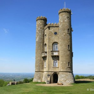
Broadway Tower, eighteenth century gothic folly.
Walk the High Street: Beautiful, wide high street lined with restaurants, tea rooms and shops, all in historic golden Cotswold-stone buildings (most from 17th and 18th centuries).
Church: There are two churches, both on the road to Snowshill. A Victorian "new" church and the old church of St. Eadburgha's.
Historic Buildings: On the High Street - Picton House, Lygon Arms, Austin House, Shakespeare Cottages (near the end of the street). The Broadway Tower is an eighteenth century gothic folly built on a hilltop just outside of town. Writer and craftsman William Morris used the tower as a country retreat. Follow a footpath from Broadway up to the tower or drive.
Nearby Villages
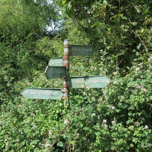
Buckland, Laverton, Stanton, Stanway: Four villages, set in a valley along the B4632 south of Broadway, with beautiful Cotswold stone houses, no shops. There is a footpath between the villages, also from Buckland over the hills to Snowshill.
Snowshill: A beautiful village on the hills above Broadway. Used in the movie "Bridget Jones's Diary". The National Trust Snowshill Manor is here.
North Cotswolds - Burford
Burford, the eastern "Gateway to the Cotswolds" on the main road from Oxford, was once a main coaching stop and a thriving market town but that changed when the railway went through in another part of the Cotswolds. Burford is not a typical golden Cotswold-stone village, but instead is a collection of mixed styles of historic buildings. The town starts at the top of a hill and slopes steeply down to the River Windrush.

Burford High Street runs downhill from the A40 to the River Windrush.
Walk the High Street: The High Street runs downhill from the A40 to the River Windrush (about ten blocks long) and is lined with historic buildings, some from as early as the 15th century. From the top of town there are lovely views out to the surrounding countryside. At the bottom of the High Street a one lane medieval bridge goes over the River Windrush. There is a small Market Hall.
Church: The church is off the High Street, to the east, near the River Windrush. It has a Norman tower and 15th century spire.
Historic Buildings: See the Almshouses near the church and weaver's cottages by the river.
Villages on the River Windrush
There are several pretty villages on either side of Burford, on the River Windrush.
Asthall: The Mitford sisters were raised in Asthall Manor (three of them are buried in the nearby Swinbrook churchyard). Nancy Mitford is well known for her novels "The Pursuit of Love" (1945) and "Love in a Cold Climate" (1949). There is a walking trail along the river to Burford. This is a nice place to experience this river.
Swinbrook: The village church has wall tombs and carved medieval chancel stalls. Some of the Mitford sisters from Asthall (Nancy, Unity and Diane) are buried here (the graves are by the church door - on your left if facing the door).
Windrush: Church has a Perpendicular tower, a Norman doorway with a double row of grotesque beakheads and 18th century table tombs in the church yard. Look for the stone in front of the church, along the road, where people on horseback dismounted.
North Cotswolds - Chipping Campden
Chipping Campden, on the northern edge of the Cotswolds, is a perfect Cotswold market town. It is situated away from the main highways and is quiet: only occasional tour buses and no fast traffic on the High Street. The Jarrold Guide - The Complete Cotswolds says Chipping Campden is "without doubt the finest of the Cotswold Wool Towns".

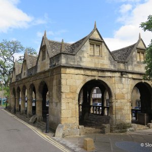
Chipping Campden Market Hall (1627) on the High Street.
Walk the High Street: The long High Street is lined with beautiful historic buildings made from the golden Cotswold stone. In the center of town is the Market Hall (1627).
Church: St James Church, off the High Street and at the edge of town bordering on the countryside, is spectacular. During the tourist season there are people in the church to answer any questions. Originally a Norman church, it was transformed in the 15th century to a magnificent wool church. See the 15th century west tower and embroideries.
Historic Buildings: On the High Street - Grevel House (medieval, 1400), The Martins (1714) and Little Martins (earlier), Woolstaplers' Hall (medieval), Dovers House (Georgian), Cotswold House Hotel (Regency). Historic almshouses (1612) are across from the church. The gateway beside the church was built in 1613 for a manor house, but the house was destroyed not long after it was built.
Nearby Villages
Blockley: Small village with a pub and a tea room. Beautiful main street and church. In the early 19th century there were several silk mills in Blockley.
North Cotswolds - Chipping Norton
Chipping Norton, the "Gateway to the Cotswolds" on the north-eastern edge, is the highest town in Oxfordshire (700 feet). This is not a tour bus destination and feels more like a "real town".
Walk the High Street: The long Market Square in the center of town is lined with lots of shops, restaurants and pubs and the 19th century Town Hall.
Church: St Mary's Parish Church, Perpendicular "Wool" church with good looking exterior, but the interior was restored during the Victorian era, so is not original. There is a row of almshouses (1640) near the church.
Historic Buildings: Bliss Mill, a large Victorian tweed mill (now converted into apartments) sits across the valley from the town.
North Cotswolds - Stow-on-the-Wold
Stow-on-the-Wold is the center of the Cotswolds; six main roads from Stow take you in all directions to the other markets towns in under 30 minutes (except for Stroud and the southern Cotswolds). Stow is a great base for exploring the Cotswolds, both northern and southern. It is close to several of the main market towns (Chipping Campden, Broadway, Burford, Cirencester) and is surrounded by beautiful Cotswold villages. As the name suggests, the town is situated on the top of a hill or "wold" at an altitude of 700 feet. The main part of the town is located off the main highway.
Walk the High Street: The High Street runs into the large Market Square which is lined with 17th and 18th century buildings; shops, pubs, tea rooms. Digbeth Street goes off from the southeast corner of the square and has more shops, tea rooms and restaurants. It meets Sheep Street, another main street in Stow.
Church: The church is just off the square and has medieval origins but was restored in the 17th century.
Historic Buildings: In the center of the Market Square there is a Medieval Cross and St Edward's Hall (1878). Look for the 18th century St Edward's House on the south side of the square.
Nearby Villages
Adlestrop: Jane Austen used to visit her uncle who was the pastor here. You can see the church and the nearby rectory (Adlestrop House) where she stayed. There was a famous pre-war poem written by Edward Thomas, about taking the train to Adlestrop. The train station is gone, but they kept the station sign and a bench (poem on Wikipedia).
Oddington: Pretty village spread out along a hillside (upper and lower parts of the village). Interesting Norman church, south of the village on the Bridlepath to Bledington, with a medieval wall painting ("Doom") on the north wall of the nave and a Jacobean pulpit.
The Slaughters: Upper and Lower Slaughter are two small villages (referred to as "The Slaughters"), a mile apart, on River Eye. Lower Slaughter is easier to drive to and is popular with tourists. The river runs right through the village. The village houses are beautiful. It is a one mile walk along the river from Lower Slaughter to Upper Slaughter.

Lower Slaughter, a picture perfect village near Stow-on-the-Wold.
North Cotswolds - Winchcombe
Winchcombe, like Burford, is not a typical golden Cotswolds town. The main street is lined with an eclectic mix of historic building styles. Locals say that Winchcombe is still a "working" town. Instead of only upscale shops for tourists it has the shops you need if you live there. Winchcombe sits in a valley surrounded by hills on three sides. This area is great for walkers/hikers and a good base for exploring the northern Cotswolds.

Winchcombe - Dent's Terrace Sudley Almshouses (1865) with their striped stonework.
Walk the High Street: The long main street runs for several blocks and is lined with interesting old row houses. Even though this street is the main road from Cheltenham to Broadway (B4632), it is not busy and the traffic does not move fast. There are another few blocks of shops and restaurants on the B4078 which goes towards Greet.
Church: The parish church, on the High Street in the center of town, was built in the late 1400s. There are around 40 grotesques (similar to gargoyles) on the edges of the roof and other spots on the outside of the church. The inside of the church is not as exciting, being redone in the Victorian era.
Historic Buildings: On the High Street south of the church - Jacobean House (17th century), Chandos Almshouses (1573), Dent's Terrace Sudley Almshouses (1865) with their striped stonework. Sudley Castle is nearby.
Nearby Villages
The Guitings: Guiting Power and Temple Guiting. In Guiting Power, where the River Windrush begins, the church has been rebuilt, but Norman doorways remain. Temple Guiting has the 18th century (Georgian) Temple Guiting House once owned by Knights Templar (parts of the Norman church remain). (Guiting is a dervative of the old English gyte meaning a flood or torrent.)
North Cotswolds – Other Market Towns
Bourton-on-the-Water: This gets my award for the most touristy town in the Cotswolds. Huge tour bus parking lot, endless trinket shops, many tea rooms. BUT this is the best town to see the River Windrush - it runs along the main street - and the tea rooms are good. Give in to the tourist impulse and stop for a visit.
Moreton-in-Marsh: Moreton-in-Marsh is a five minute drive north of Stow-on-the-Wold. The main part of town is along the highway, but this is not a busy road. Moreton does not get as many tour buses as Stow, but it is also busy with tourists. Lots of shops, restaurants and pubs. Stay here if you want to see the Cotswolds without a car. The train from Oxford and London stops here. There are buses to other towns.
South Cotswolds - Cirencester
Cirencester, the "capital of the Cotswolds", is a busy Cotswold market town with roots in Ancient Rome. When the Romans conquered Britain almost 2,000 years ago (43 AD) they built the town of Corinium, second only to Londinium (London) in size. Corinium became Cirencester and there are still Roman remains. Three Roman Roads meet in Cirencester - Fosse Way, Ermin Way and Akeman Street. There are remains of a Roman amphitheater outside of town.
Cirencester is a large town (second only to Stroud in this list of Cotswold market towns) full of shops, pubs and restaurants. The River Churn, a tributary of the River Thames, runs through the town. The main highways use a Ring Road around Cirencester and do not go into the town.
Walk the High Street: Market Place is the main street in the center of Cirencester. The church is at one end and the rest is lined with historic buildings, some from as early as the Tudor era.
Church: St John the Baptist is a beautiful 15th century "wool" church with a Perpendicular tower and porch (south porch, three storeys high, built around 1490), medieval stained glass, a painted "wine glass" pulpit, and historic brasses (15th century).
Historic Buildings: On Market Place, the Fleece Hotel, a timber frame Tudor building, and the Corn Exchange, with carvings on the outside. In Spitalgate, the arcade of St. John's Hospital, founded by Henry II. The center of Cirencester is worth exploring, especially these streets north of the church: Dollar, Thomas, Black Jack, Coxwell, Park and Cecily Hill. Many of the buildings on these streets are medieval.
Corinium Museum: A good collection of Roman remains from the area, including mosaics.
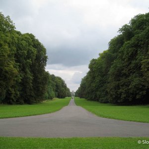
Cirencester Park: At the end of Cicily Hill, just a few blocks from the center of town, is the Bathurst mansion (built by the first Earl of Bathurst, 1714 - 18) and the fabulous Cirencester Park. This is part of the Bathurst Estate which covers a lot of the woodland in this area and is open to walkers. The main walk in the park, the Broad Ride is lined with large beech and horse-chestnut trees and is paved until it reaches the top of the hill.
Nearby Villages
Bibury: William Morris said Bibury was the most beautiful village in England and not much has changed since he lived in this area (near Lechlade). A tour bus destination, but well worth visiting. See the historic Arlington Row (National Trust), sheep houses built in the 14th century and turned into weavers' cottages 200 years later.

Bibury, the Arlington Row, cottages built in the 14th century.
Cotswold Water Park: South of Cirencester, old gravel pits were filled with water to make lakes, which now attract birds and wildlife. There are parks and walking trails around the lakes. If you are looking for golf, fishing, canoeing and sailing, this is the place to go.
Northleach: Quiet village at the intersection of the A40 and the A419, but off the main roads. It is on the River Leach, but you cannot see much of the river in the town. Wool church rebuilt in the 15th century (Perpendicular style), with brasses of wool merchants.
Sapperton: Beautiful golden Cotswold village sitting above the River Frome, north of the A419 between Cirencester and Stroud. 18th century church with a good interior.
South Cotswolds - Lechlade
Lechlade is in the south-eastern corner of the Cotswolds (another Gateway to the Cotswolds). The Rivers Coln and Leach join the River Thames here. The Thames and Severn Canal ends in Lechlade (connecting the River Thames here with the River Severn west of Stroud). There are many delightful Cotswold villages nearby. The River Thames runs south of the main street and Market Square, so many of the pubs and hotels on the main street have the River Thames behind them.
Market Square: The market square is where the main road makes a 90 degree turn, in front of the church. It is lined with 18th and 19th century buildings.
Church: St Lawrence, a Perpendicular wool church (1476), with a tall tower and spire. There is a wooden carved doorway inside (leading to the vestry) and a 15th century brass.
Historic Buildings: Two historic bridges - Halfpenny Bridge, over the River Thames, south of the High Street, on Thames Street and St John's Bridge (1220) over the Thames at St John's Lock, on the Faringdon Road (A417) outside of town. The New Inn on the Market Square is a well-preserved historic building.
Nearby Villages
Eastleach Turville and Eastleach Martin: Two villages separated by the River Leach. Historic churches sit on each side of the river (St Andrew's and Church of St Michael and St Martin - 12th century). A stone walking bridge separates the villages. The river near the bridge is lined with daffodils in the spring.
Fairford: 15th century church with medieval stained-glass windows.
South Cotswolds - Minchinhampton
Minchinhampton, or "Minch" as it is known to its friends, is a delightful town. It is small (barely makes it into my "market town" category) and is in a relatively non-touristed part of the Cotswolds. Minch is a "royal" town, with Gatcombe Park, Princess Anne's residence, on the outskirts between Minch and Avening.
Minchinhampton sits on the edge of Minchinhampton Common, 500 acres owned by the National Trust. The commons are wide open fields sitting high above the Stroud Valley. Rodborough Common, also owned by the National Trust, are to the north and look down to Stroud. There is a large golf course on one side of Minchinhampton Common (they stop play when walkers are in the area) and the remains of Iron Age Bulwarks on the other side, close to the town. There are trails across the common and in the woods around the edges.
Walk the High Street: The High Street is an eclectic mix of style of historic buildings.
Market Hall: The Market Hall is at the north end of the High Street.
Church: Holy Trinity Church has a 14th century south transept and interesting brasses.
Historic Buildings: 18th century Crown Hotel on the High Street. The most interesting spot in Minch, is the intersection at the south end of the High Street. From here, walk down Well Hill street for a block (we rented a house on this block a few years ago). Return to the intersection and walk along W End street, west from the end of the High Street, to see the blocks of charming row houses.
Minchinhampton and Rodborough Commons: Over 600 acres of open space, owned by the National Trust, sitting high above the valleys around Stroud. These commons feel a bit like a "moor", like Dartmoor, but are smaller and more tame. When the weather is bad, it will be worse up on the high and exposed commons, but this is a good place to walk after a rain because the water drains off quickly (there is limestone under the ground). The Minchinhampton Commons is larger. The Rodborough Commons are to the north and look over Stroud.
In the summer, cattle roams free on the commons which means they can wander out onto the roads. (If driving in England on narrow roads, on a different side than you are used to isn't exciting enough, then add in the possibility of a cow stepping out in front of you.)
South Cotswolds - Nailsworth
Nailsworth is not your typical Cotswold market town and is frequently overlooked by tourists. It is not as pretty as some of the other towns and has modern sprawl (most from the 1970s) but is a great place to visit or stay. Part of the downside of Nailsworth is the main commercial area along the busy A46 highway, but if you park and explore the town you will find the traffic does not move fast, the sidewalks are wide, there are many places to easily cross the road and there are other commercial areas off this main street.

Nailsworth, center of town.
Walk the High Street: A clock tower and a war memorial mark the main roundabout in Nailsworth where the A46 highway (Bridge Street and Fountain Street) meets the B4014 (George Street) and Spring Hill. The main residential areas are above town on the east-facing side of the valley. The commercial part of town is along Bridge Street, Fountain Street and George Street, but there is another quiet area one block off the A46 that you get to from Spring Hill. This is Old Market which ends at Cossack Square (and the pub).
Historic Buildings: There are eight historic mills in this area. There are historic mill worker cottages in a small neighborhood called Watledge on the east side of the valley, behind Egypt Mill. Walk up Spring Hill on the west side of the valley to see several historic homes - Spring Hill House (1789), the Upper House (early 1700s). In the center of town, Chestnut Hill has Stokescroft (18th century) and The Friends Meeting House (17th century). On George Street look for the large copper kettle hanging over the north sidewalk.
Historic Mills: Mills built in the 17th and 18th centuries have been converted to businesses or apartments. The last two working mills shut down in the last twenty years. The Nailsworth Tourist Office has good information about these mills.
South Cotswolds - Stroud and the Five Valleys
Stroud is located on the north slopes of the River Frome where five valleys meet. Stroud and the Five Valleys was an industrial center in the 18th and 19th centuries. Rivers flowed through the area, sheep were raised on the hillsides and commons above the town. Many mills still remain - you see them along the valley floors. None are working mills but have been converted to apartments or workshops.
Some say Stroud is not really a Cotswold town. It is not a perfect "golden" village but is a regular mid-sized town (population around 20,000) with a somewhat ugly High Street filled with regular stores. It is frequently described as "gritty". Others say that Stroud is the only "real" Cotswold town left - not a place of perfectly restored second homes for wealthy Londoners and vacationers, but instead a place where people live and work like they did in all the Cotswold towns a few decades ago. Stroud has a train station with trains north to Gloucester and Cheltenham or east to London.
Walk the High Street: The High Street in Stroud is a pedestrian street lined with shops and cafes. There is more shopping on King Street at the end of the pedestrian part of the High Street and on the small streets off the High Street.
Market Hall: Stroud is a Market Town historically, but the Market Hall is new, on Cornhill Street just off the High Street. Come here for the Saturday Farmers' Market.
Church: The St Laurence Church is was rebuilt in Victorian times (19th century) but the medieval tower and spire were kept. It is a bit hard to find and is off the High Street (entrance from The Shambles). See the pyramid Hollings Tomb in the churchyard, from 1805 when John Hollings did not want to be buried in the ground.
Stroud Cemetery: In 1854 a new cemetary was opened on the slopes above Stroud (on the Bisley Road just after the Horns Road turnoff). See the Victorian architecture of the twin chapels and the interesting graves. The cemetery was divided into three sections, for Conformists, Non-Comformists and Paupers. It is also a local Nature Preserve.
The Five Valleys (that meet at Stroud): Frome Valley (called the Golden Valley by Queen Victoria when she visited), Nailsworth Valley, Painswick Valley, Slad Valley, Toadsmoor Valley.
Cotswold Canal: The Cotswold Canals Trust is restoring the canal that runs from the River Severn, through Stroud, into Wiltshire, to join the River Thames at Lechlade on the eastern edge of the Cotswolds. This canal is made up of two canals that meet in Stroud: the Stroudwater Navigation (from the Severn to Stroud) and the Thames & Severn Canal (from Stroud to Lechlade). This canal was used during the 18th and 19th centuries but fell into disuse when trains took over from canals for transporting goods. Parts have been restored, but much of it is not yet done. One very interesting feature of this canal is a two mile tunnel that starts near Sapperton and ends at Coates (beside the Tunnel Inn pub). The tunnel has collapsed, but the start and end are impressive.
Nearby Villages
Bisley: Beautiful stone village high above Stroud. There are beautiful houses and a good church with a 13th century tall spire and statue inside of a knight. Beside the church are two historic houses - Over Court and Jaynes Court.
Chalford: A village built in terraces on the steep northern slope of the Frome Valley. Many of the houses were weavers' houses from the time when the mills were active. Climb through the village on steep stairs. Get to Chalford off the A419 east of Stroud, but don't drive into the village, the roads are shockingly narrow.
Painswick: Pretty village with an exceptional church, with 17th century spire, table tombs and historic clipped Yew trees, many planted in 1792. Many Georgian style buildings on lovely lanes off the main road. Painswick Rococo Gardens are north of town. Painswick Beacon, a view point, is outside of town.

Painswick, 99 Yew trees in the churchyard.
Selsey: Victorian church with stained glass by Pre-Raphaelites (William Morris, Ford Madox Brown, Burne-Jones, Rossetti, Philip Webb).
Slad: Small village in the Slad Valley north of Stroud. Laurie Lee, the author of Cider with Rosie lived here.
Coopers Hill: Hillside north of Painswick, famous for cheese rolling races held in the spring (Whit Monday).
South Cotswolds - Tetbury
Tetbury, in the southern most part of the Cotswolds, is known for its antique stores and the Royals who live nearby. This area is flatter than the area around Stroud and Nailsworth to the north - there is more of a "wide-open" feel to the countryside. Tetbury is a fun and lively town, filled with good shops and restaurants. HRH The Prince of Wales (Prince Charles) lives near Tetbury in Highgrove House.

Tetbury Market and center of town.
Walk the High Street: The town centers around the Market House, with the main shopping streets radiating out from there.
Market House: The historic Market House (1655) in the center of town is larger than most in the Cotswolds, with three rows of pillars. Antique markets are sometimes held here.
Church: St Mary, an 18th century Gothic church, is on Church Street, south of Market Place and near the public car park. See the woodwork on the box pews and the interesting churchyard.
Historic Buildings: Many 17th and 18th century homes. Long Street, off the Market Place, is lined with historic buildings. Look for The Close, now a hotel, but up until 1950 a private residence.
Chipping Steps: From the Market Place take Chipping St to the parking lot. At the end of the parking lot are the Chipping Steps, medieval steps with a row of historic houses on one side. At the bottom of the steps, find the historic houses The Croft and Croft Cottage.
Nearby Villages
Castle Combe: A beautiful Cotswold stone village, which is not in the Cotswolds by some definitions. The movie "Doctor Doolittle" was filmed here in 1966, and more recently "Stardust" was filmed here in 2007.
Lacock: A well preserved 13th century historic village with medieval abbey (National Trust). There is a somewhat "Disneyland" feel to the village, but the streets and buildings are beautiful. Lacock is used for many films: Harry Potter, Pride and Prejudice (1995 version), Cranford Chronicles (2007) and The Other Boleyn Girl (2007).
South Cotswolds - Wotton-under-Edge
Wotton-under-Edge, in the south-western corner of the Cotswolds, is too far away from the center of the Cotswolds to be a tourist destination, so it has retained a "real town" feel. This is a nice corner of the Cotswolds, with interesting villages and some good walking areas.
Walk the High Street: An interesting High Street lined with shops and some historic buildings.
Church: St Mary the Virgin, wool church (13th century) with Perpendicular tower (14th century) and 14th century brasses of Lord and Lady Berkeley (copies nearby are for doing "rubbings"). South porch has restored 13th century doorway, sundial and priest's chambers above.
Historic Buildings: The Perry and Dawes Almhouses in Church Street (17th and 18th century), Ann Bearpacker Almshouses in opposite the church (19th century). Tolsey House on the corner of the High Street and Market Street with a Victoria Jubilee clock (originally 16th century).
Nearby Villages
Dursley: Market town with an 18th century Market House in the center (Town Hall is on top of the Market House). The church has a Perpendicular porch and a Gothic-style tower.
Uley: Small village in the southern Cotswolds, near Owlpen Manor.
Resources
@Eleanor posted photos of churches in the Cotswolds in the Trip Reports forum.
More Photos
See more photos in my photo gallery for the Cotswolds.
The Cotswolds is a small area of about 800 square miles. You can drive across from Burford to Cheltenham in an hour or drive north to south from Chipping Campden to Bath in 90 minutes. It may be small, but this area is packed with things to do and see. I divide the Cotswolds into North and South, using the A40 highway that goes from Oxford to Cheltenham as the dividing line, then list the market towns for each section.
Each market town listed below is a good place to base your Cotswold vacation. You will find good shops, pubs and tea rooms in all these towns. For a more rural setting, you choose one of the nearby villages.
My Google Map for the Cotswolds
View on Google Maps.View: https://www.google.com/maps/d/embed?mid=13M4ZyXEtrTDnb9ieFGTeQ4qtTDw
North Cotswolds - Broadway
Broadway is a perfect golden Cotswold village, off the main roads, with a long, wide high street (a "broad" way) lined with beautifully restored old houses. Broadway is smaller than some of the other market towns on our list, but it is the center of an area with beautiful villages and countryside.
Broadway Tower, eighteenth century gothic folly.
Walk the High Street: Beautiful, wide high street lined with restaurants, tea rooms and shops, all in historic golden Cotswold-stone buildings (most from 17th and 18th centuries).
Church: There are two churches, both on the road to Snowshill. A Victorian "new" church and the old church of St. Eadburgha's.
Historic Buildings: On the High Street - Picton House, Lygon Arms, Austin House, Shakespeare Cottages (near the end of the street). The Broadway Tower is an eighteenth century gothic folly built on a hilltop just outside of town. Writer and craftsman William Morris used the tower as a country retreat. Follow a footpath from Broadway up to the tower or drive.
Nearby Villages
Buckland, Laverton, Stanton, Stanway: Four villages, set in a valley along the B4632 south of Broadway, with beautiful Cotswold stone houses, no shops. There is a footpath between the villages, also from Buckland over the hills to Snowshill.
Snowshill: A beautiful village on the hills above Broadway. Used in the movie "Bridget Jones's Diary". The National Trust Snowshill Manor is here.
North Cotswolds - Burford
Burford, the eastern "Gateway to the Cotswolds" on the main road from Oxford, was once a main coaching stop and a thriving market town but that changed when the railway went through in another part of the Cotswolds. Burford is not a typical golden Cotswold-stone village, but instead is a collection of mixed styles of historic buildings. The town starts at the top of a hill and slopes steeply down to the River Windrush.
Burford High Street runs downhill from the A40 to the River Windrush.
Walk the High Street: The High Street runs downhill from the A40 to the River Windrush (about ten blocks long) and is lined with historic buildings, some from as early as the 15th century. From the top of town there are lovely views out to the surrounding countryside. At the bottom of the High Street a one lane medieval bridge goes over the River Windrush. There is a small Market Hall.
Church: The church is off the High Street, to the east, near the River Windrush. It has a Norman tower and 15th century spire.
Historic Buildings: See the Almshouses near the church and weaver's cottages by the river.
Villages on the River Windrush
There are several pretty villages on either side of Burford, on the River Windrush.
Asthall: The Mitford sisters were raised in Asthall Manor (three of them are buried in the nearby Swinbrook churchyard). Nancy Mitford is well known for her novels "The Pursuit of Love" (1945) and "Love in a Cold Climate" (1949). There is a walking trail along the river to Burford. This is a nice place to experience this river.
Swinbrook: The village church has wall tombs and carved medieval chancel stalls. Some of the Mitford sisters from Asthall (Nancy, Unity and Diane) are buried here (the graves are by the church door - on your left if facing the door).
Windrush: Church has a Perpendicular tower, a Norman doorway with a double row of grotesque beakheads and 18th century table tombs in the church yard. Look for the stone in front of the church, along the road, where people on horseback dismounted.
North Cotswolds - Chipping Campden
Chipping Campden, on the northern edge of the Cotswolds, is a perfect Cotswold market town. It is situated away from the main highways and is quiet: only occasional tour buses and no fast traffic on the High Street. The Jarrold Guide - The Complete Cotswolds says Chipping Campden is "without doubt the finest of the Cotswold Wool Towns".
Chipping Campden Market Hall (1627) on the High Street.
Walk the High Street: The long High Street is lined with beautiful historic buildings made from the golden Cotswold stone. In the center of town is the Market Hall (1627).
Church: St James Church, off the High Street and at the edge of town bordering on the countryside, is spectacular. During the tourist season there are people in the church to answer any questions. Originally a Norman church, it was transformed in the 15th century to a magnificent wool church. See the 15th century west tower and embroideries.
Historic Buildings: On the High Street - Grevel House (medieval, 1400), The Martins (1714) and Little Martins (earlier), Woolstaplers' Hall (medieval), Dovers House (Georgian), Cotswold House Hotel (Regency). Historic almshouses (1612) are across from the church. The gateway beside the church was built in 1613 for a manor house, but the house was destroyed not long after it was built.
Nearby Villages
Blockley: Small village with a pub and a tea room. Beautiful main street and church. In the early 19th century there were several silk mills in Blockley.
North Cotswolds - Chipping Norton
Chipping Norton, the "Gateway to the Cotswolds" on the north-eastern edge, is the highest town in Oxfordshire (700 feet). This is not a tour bus destination and feels more like a "real town".
Walk the High Street: The long Market Square in the center of town is lined with lots of shops, restaurants and pubs and the 19th century Town Hall.
Church: St Mary's Parish Church, Perpendicular "Wool" church with good looking exterior, but the interior was restored during the Victorian era, so is not original. There is a row of almshouses (1640) near the church.
Historic Buildings: Bliss Mill, a large Victorian tweed mill (now converted into apartments) sits across the valley from the town.
North Cotswolds - Stow-on-the-Wold
Stow-on-the-Wold is the center of the Cotswolds; six main roads from Stow take you in all directions to the other markets towns in under 30 minutes (except for Stroud and the southern Cotswolds). Stow is a great base for exploring the Cotswolds, both northern and southern. It is close to several of the main market towns (Chipping Campden, Broadway, Burford, Cirencester) and is surrounded by beautiful Cotswold villages. As the name suggests, the town is situated on the top of a hill or "wold" at an altitude of 700 feet. The main part of the town is located off the main highway.
Walk the High Street: The High Street runs into the large Market Square which is lined with 17th and 18th century buildings; shops, pubs, tea rooms. Digbeth Street goes off from the southeast corner of the square and has more shops, tea rooms and restaurants. It meets Sheep Street, another main street in Stow.
Church: The church is just off the square and has medieval origins but was restored in the 17th century.
Historic Buildings: In the center of the Market Square there is a Medieval Cross and St Edward's Hall (1878). Look for the 18th century St Edward's House on the south side of the square.
Nearby Villages
Adlestrop: Jane Austen used to visit her uncle who was the pastor here. You can see the church and the nearby rectory (Adlestrop House) where she stayed. There was a famous pre-war poem written by Edward Thomas, about taking the train to Adlestrop. The train station is gone, but they kept the station sign and a bench (poem on Wikipedia).
Oddington: Pretty village spread out along a hillside (upper and lower parts of the village). Interesting Norman church, south of the village on the Bridlepath to Bledington, with a medieval wall painting ("Doom") on the north wall of the nave and a Jacobean pulpit.
The Slaughters: Upper and Lower Slaughter are two small villages (referred to as "The Slaughters"), a mile apart, on River Eye. Lower Slaughter is easier to drive to and is popular with tourists. The river runs right through the village. The village houses are beautiful. It is a one mile walk along the river from Lower Slaughter to Upper Slaughter.
Lower Slaughter, a picture perfect village near Stow-on-the-Wold.
North Cotswolds - Winchcombe
Winchcombe, like Burford, is not a typical golden Cotswolds town. The main street is lined with an eclectic mix of historic building styles. Locals say that Winchcombe is still a "working" town. Instead of only upscale shops for tourists it has the shops you need if you live there. Winchcombe sits in a valley surrounded by hills on three sides. This area is great for walkers/hikers and a good base for exploring the northern Cotswolds.
Winchcombe - Dent's Terrace Sudley Almshouses (1865) with their striped stonework.
Walk the High Street: The long main street runs for several blocks and is lined with interesting old row houses. Even though this street is the main road from Cheltenham to Broadway (B4632), it is not busy and the traffic does not move fast. There are another few blocks of shops and restaurants on the B4078 which goes towards Greet.
Church: The parish church, on the High Street in the center of town, was built in the late 1400s. There are around 40 grotesques (similar to gargoyles) on the edges of the roof and other spots on the outside of the church. The inside of the church is not as exciting, being redone in the Victorian era.
Historic Buildings: On the High Street south of the church - Jacobean House (17th century), Chandos Almshouses (1573), Dent's Terrace Sudley Almshouses (1865) with their striped stonework. Sudley Castle is nearby.
Nearby Villages
The Guitings: Guiting Power and Temple Guiting. In Guiting Power, where the River Windrush begins, the church has been rebuilt, but Norman doorways remain. Temple Guiting has the 18th century (Georgian) Temple Guiting House once owned by Knights Templar (parts of the Norman church remain). (Guiting is a dervative of the old English gyte meaning a flood or torrent.)
North Cotswolds – Other Market Towns
Bourton-on-the-Water: This gets my award for the most touristy town in the Cotswolds. Huge tour bus parking lot, endless trinket shops, many tea rooms. BUT this is the best town to see the River Windrush - it runs along the main street - and the tea rooms are good. Give in to the tourist impulse and stop for a visit.
Moreton-in-Marsh: Moreton-in-Marsh is a five minute drive north of Stow-on-the-Wold. The main part of town is along the highway, but this is not a busy road. Moreton does not get as many tour buses as Stow, but it is also busy with tourists. Lots of shops, restaurants and pubs. Stay here if you want to see the Cotswolds without a car. The train from Oxford and London stops here. There are buses to other towns.
South Cotswolds - Cirencester
Cirencester, the "capital of the Cotswolds", is a busy Cotswold market town with roots in Ancient Rome. When the Romans conquered Britain almost 2,000 years ago (43 AD) they built the town of Corinium, second only to Londinium (London) in size. Corinium became Cirencester and there are still Roman remains. Three Roman Roads meet in Cirencester - Fosse Way, Ermin Way and Akeman Street. There are remains of a Roman amphitheater outside of town.
Cirencester is a large town (second only to Stroud in this list of Cotswold market towns) full of shops, pubs and restaurants. The River Churn, a tributary of the River Thames, runs through the town. The main highways use a Ring Road around Cirencester and do not go into the town.
Walk the High Street: Market Place is the main street in the center of Cirencester. The church is at one end and the rest is lined with historic buildings, some from as early as the Tudor era.
Church: St John the Baptist is a beautiful 15th century "wool" church with a Perpendicular tower and porch (south porch, three storeys high, built around 1490), medieval stained glass, a painted "wine glass" pulpit, and historic brasses (15th century).
Historic Buildings: On Market Place, the Fleece Hotel, a timber frame Tudor building, and the Corn Exchange, with carvings on the outside. In Spitalgate, the arcade of St. John's Hospital, founded by Henry II. The center of Cirencester is worth exploring, especially these streets north of the church: Dollar, Thomas, Black Jack, Coxwell, Park and Cecily Hill. Many of the buildings on these streets are medieval.
Corinium Museum: A good collection of Roman remains from the area, including mosaics.
Cirencester Park: At the end of Cicily Hill, just a few blocks from the center of town, is the Bathurst mansion (built by the first Earl of Bathurst, 1714 - 18) and the fabulous Cirencester Park. This is part of the Bathurst Estate which covers a lot of the woodland in this area and is open to walkers. The main walk in the park, the Broad Ride is lined with large beech and horse-chestnut trees and is paved until it reaches the top of the hill.
Nearby Villages
Bibury: William Morris said Bibury was the most beautiful village in England and not much has changed since he lived in this area (near Lechlade). A tour bus destination, but well worth visiting. See the historic Arlington Row (National Trust), sheep houses built in the 14th century and turned into weavers' cottages 200 years later.
Bibury, the Arlington Row, cottages built in the 14th century.
Cotswold Water Park: South of Cirencester, old gravel pits were filled with water to make lakes, which now attract birds and wildlife. There are parks and walking trails around the lakes. If you are looking for golf, fishing, canoeing and sailing, this is the place to go.
Northleach: Quiet village at the intersection of the A40 and the A419, but off the main roads. It is on the River Leach, but you cannot see much of the river in the town. Wool church rebuilt in the 15th century (Perpendicular style), with brasses of wool merchants.
Sapperton: Beautiful golden Cotswold village sitting above the River Frome, north of the A419 between Cirencester and Stroud. 18th century church with a good interior.
South Cotswolds - Lechlade
Lechlade is in the south-eastern corner of the Cotswolds (another Gateway to the Cotswolds). The Rivers Coln and Leach join the River Thames here. The Thames and Severn Canal ends in Lechlade (connecting the River Thames here with the River Severn west of Stroud). There are many delightful Cotswold villages nearby. The River Thames runs south of the main street and Market Square, so many of the pubs and hotels on the main street have the River Thames behind them.
Market Square: The market square is where the main road makes a 90 degree turn, in front of the church. It is lined with 18th and 19th century buildings.
Church: St Lawrence, a Perpendicular wool church (1476), with a tall tower and spire. There is a wooden carved doorway inside (leading to the vestry) and a 15th century brass.
Historic Buildings: Two historic bridges - Halfpenny Bridge, over the River Thames, south of the High Street, on Thames Street and St John's Bridge (1220) over the Thames at St John's Lock, on the Faringdon Road (A417) outside of town. The New Inn on the Market Square is a well-preserved historic building.
Nearby Villages
Eastleach Turville and Eastleach Martin: Two villages separated by the River Leach. Historic churches sit on each side of the river (St Andrew's and Church of St Michael and St Martin - 12th century). A stone walking bridge separates the villages. The river near the bridge is lined with daffodils in the spring.
Fairford: 15th century church with medieval stained-glass windows.
South Cotswolds - Minchinhampton
Minchinhampton, or "Minch" as it is known to its friends, is a delightful town. It is small (barely makes it into my "market town" category) and is in a relatively non-touristed part of the Cotswolds. Minch is a "royal" town, with Gatcombe Park, Princess Anne's residence, on the outskirts between Minch and Avening.
Minchinhampton sits on the edge of Minchinhampton Common, 500 acres owned by the National Trust. The commons are wide open fields sitting high above the Stroud Valley. Rodborough Common, also owned by the National Trust, are to the north and look down to Stroud. There is a large golf course on one side of Minchinhampton Common (they stop play when walkers are in the area) and the remains of Iron Age Bulwarks on the other side, close to the town. There are trails across the common and in the woods around the edges.
Walk the High Street: The High Street is an eclectic mix of style of historic buildings.
Market Hall: The Market Hall is at the north end of the High Street.
Church: Holy Trinity Church has a 14th century south transept and interesting brasses.
Historic Buildings: 18th century Crown Hotel on the High Street. The most interesting spot in Minch, is the intersection at the south end of the High Street. From here, walk down Well Hill street for a block (we rented a house on this block a few years ago). Return to the intersection and walk along W End street, west from the end of the High Street, to see the blocks of charming row houses.
Minchinhampton and Rodborough Commons: Over 600 acres of open space, owned by the National Trust, sitting high above the valleys around Stroud. These commons feel a bit like a "moor", like Dartmoor, but are smaller and more tame. When the weather is bad, it will be worse up on the high and exposed commons, but this is a good place to walk after a rain because the water drains off quickly (there is limestone under the ground). The Minchinhampton Commons is larger. The Rodborough Commons are to the north and look over Stroud.
In the summer, cattle roams free on the commons which means they can wander out onto the roads. (If driving in England on narrow roads, on a different side than you are used to isn't exciting enough, then add in the possibility of a cow stepping out in front of you.)
South Cotswolds - Nailsworth
Nailsworth is not your typical Cotswold market town and is frequently overlooked by tourists. It is not as pretty as some of the other towns and has modern sprawl (most from the 1970s) but is a great place to visit or stay. Part of the downside of Nailsworth is the main commercial area along the busy A46 highway, but if you park and explore the town you will find the traffic does not move fast, the sidewalks are wide, there are many places to easily cross the road and there are other commercial areas off this main street.
Nailsworth, center of town.
Walk the High Street: A clock tower and a war memorial mark the main roundabout in Nailsworth where the A46 highway (Bridge Street and Fountain Street) meets the B4014 (George Street) and Spring Hill. The main residential areas are above town on the east-facing side of the valley. The commercial part of town is along Bridge Street, Fountain Street and George Street, but there is another quiet area one block off the A46 that you get to from Spring Hill. This is Old Market which ends at Cossack Square (and the pub).
Historic Buildings: There are eight historic mills in this area. There are historic mill worker cottages in a small neighborhood called Watledge on the east side of the valley, behind Egypt Mill. Walk up Spring Hill on the west side of the valley to see several historic homes - Spring Hill House (1789), the Upper House (early 1700s). In the center of town, Chestnut Hill has Stokescroft (18th century) and The Friends Meeting House (17th century). On George Street look for the large copper kettle hanging over the north sidewalk.
Historic Mills: Mills built in the 17th and 18th centuries have been converted to businesses or apartments. The last two working mills shut down in the last twenty years. The Nailsworth Tourist Office has good information about these mills.
- Egypt Mill: On the A46 in the center of town, now a restaurant and hotel.
- Nailsworth Mill: On the western side of the valley, on Pensile Road.
- Day's Mill: In the center of town on Old Market St.
- Price's Mill: On Miry Brook off Newmarket Road in the town center.
- Dunkirk Mills: On the west side of the A46 about a mile north of Nailsworth. This mill is now apartments. You can pull into the large parking lot and have a good look at the mill. The Nailsworth River runs under the building. The Pedestrian/Cycle Trail runs behind it.
- On the B4058 to Horsley there are the following mills - Lock's Mill, Gigg Mill, Ruskin Mill, Horsley Mill. Ruskin Mill has a small cafe, but there is no parking (except handicap parking). Instead park at Horsley Mill and take the trail along the river down to Ruskin Mill (about 20 minutes). There is a trout farm between the two mills.
- On the A46 to Stroud you see more mills and there are mills on the River Frome in Stroud.
South Cotswolds - Stroud and the Five Valleys
Stroud is located on the north slopes of the River Frome where five valleys meet. Stroud and the Five Valleys was an industrial center in the 18th and 19th centuries. Rivers flowed through the area, sheep were raised on the hillsides and commons above the town. Many mills still remain - you see them along the valley floors. None are working mills but have been converted to apartments or workshops.
Some say Stroud is not really a Cotswold town. It is not a perfect "golden" village but is a regular mid-sized town (population around 20,000) with a somewhat ugly High Street filled with regular stores. It is frequently described as "gritty". Others say that Stroud is the only "real" Cotswold town left - not a place of perfectly restored second homes for wealthy Londoners and vacationers, but instead a place where people live and work like they did in all the Cotswold towns a few decades ago. Stroud has a train station with trains north to Gloucester and Cheltenham or east to London.
Walk the High Street: The High Street in Stroud is a pedestrian street lined with shops and cafes. There is more shopping on King Street at the end of the pedestrian part of the High Street and on the small streets off the High Street.
Market Hall: Stroud is a Market Town historically, but the Market Hall is new, on Cornhill Street just off the High Street. Come here for the Saturday Farmers' Market.
Church: The St Laurence Church is was rebuilt in Victorian times (19th century) but the medieval tower and spire were kept. It is a bit hard to find and is off the High Street (entrance from The Shambles). See the pyramid Hollings Tomb in the churchyard, from 1805 when John Hollings did not want to be buried in the ground.
Stroud Cemetery: In 1854 a new cemetary was opened on the slopes above Stroud (on the Bisley Road just after the Horns Road turnoff). See the Victorian architecture of the twin chapels and the interesting graves. The cemetery was divided into three sections, for Conformists, Non-Comformists and Paupers. It is also a local Nature Preserve.
The Five Valleys (that meet at Stroud): Frome Valley (called the Golden Valley by Queen Victoria when she visited), Nailsworth Valley, Painswick Valley, Slad Valley, Toadsmoor Valley.
Cotswold Canal: The Cotswold Canals Trust is restoring the canal that runs from the River Severn, through Stroud, into Wiltshire, to join the River Thames at Lechlade on the eastern edge of the Cotswolds. This canal is made up of two canals that meet in Stroud: the Stroudwater Navigation (from the Severn to Stroud) and the Thames & Severn Canal (from Stroud to Lechlade). This canal was used during the 18th and 19th centuries but fell into disuse when trains took over from canals for transporting goods. Parts have been restored, but much of it is not yet done. One very interesting feature of this canal is a two mile tunnel that starts near Sapperton and ends at Coates (beside the Tunnel Inn pub). The tunnel has collapsed, but the start and end are impressive.
Nearby Villages
Bisley: Beautiful stone village high above Stroud. There are beautiful houses and a good church with a 13th century tall spire and statue inside of a knight. Beside the church are two historic houses - Over Court and Jaynes Court.
Chalford: A village built in terraces on the steep northern slope of the Frome Valley. Many of the houses were weavers' houses from the time when the mills were active. Climb through the village on steep stairs. Get to Chalford off the A419 east of Stroud, but don't drive into the village, the roads are shockingly narrow.
Painswick: Pretty village with an exceptional church, with 17th century spire, table tombs and historic clipped Yew trees, many planted in 1792. Many Georgian style buildings on lovely lanes off the main road. Painswick Rococo Gardens are north of town. Painswick Beacon, a view point, is outside of town.
Painswick, 99 Yew trees in the churchyard.
Selsey: Victorian church with stained glass by Pre-Raphaelites (William Morris, Ford Madox Brown, Burne-Jones, Rossetti, Philip Webb).
Slad: Small village in the Slad Valley north of Stroud. Laurie Lee, the author of Cider with Rosie lived here.
Coopers Hill: Hillside north of Painswick, famous for cheese rolling races held in the spring (Whit Monday).
South Cotswolds - Tetbury
Tetbury, in the southern most part of the Cotswolds, is known for its antique stores and the Royals who live nearby. This area is flatter than the area around Stroud and Nailsworth to the north - there is more of a "wide-open" feel to the countryside. Tetbury is a fun and lively town, filled with good shops and restaurants. HRH The Prince of Wales (Prince Charles) lives near Tetbury in Highgrove House.
Tetbury Market and center of town.
Walk the High Street: The town centers around the Market House, with the main shopping streets radiating out from there.
Market House: The historic Market House (1655) in the center of town is larger than most in the Cotswolds, with three rows of pillars. Antique markets are sometimes held here.
Church: St Mary, an 18th century Gothic church, is on Church Street, south of Market Place and near the public car park. See the woodwork on the box pews and the interesting churchyard.
Historic Buildings: Many 17th and 18th century homes. Long Street, off the Market Place, is lined with historic buildings. Look for The Close, now a hotel, but up until 1950 a private residence.
Chipping Steps: From the Market Place take Chipping St to the parking lot. At the end of the parking lot are the Chipping Steps, medieval steps with a row of historic houses on one side. At the bottom of the steps, find the historic houses The Croft and Croft Cottage.
Nearby Villages
Castle Combe: A beautiful Cotswold stone village, which is not in the Cotswolds by some definitions. The movie "Doctor Doolittle" was filmed here in 1966, and more recently "Stardust" was filmed here in 2007.
Lacock: A well preserved 13th century historic village with medieval abbey (National Trust). There is a somewhat "Disneyland" feel to the village, but the streets and buildings are beautiful. Lacock is used for many films: Harry Potter, Pride and Prejudice (1995 version), Cranford Chronicles (2007) and The Other Boleyn Girl (2007).
South Cotswolds - Wotton-under-Edge
Wotton-under-Edge, in the south-western corner of the Cotswolds, is too far away from the center of the Cotswolds to be a tourist destination, so it has retained a "real town" feel. This is a nice corner of the Cotswolds, with interesting villages and some good walking areas.
Walk the High Street: An interesting High Street lined with shops and some historic buildings.
Church: St Mary the Virgin, wool church (13th century) with Perpendicular tower (14th century) and 14th century brasses of Lord and Lady Berkeley (copies nearby are for doing "rubbings"). South porch has restored 13th century doorway, sundial and priest's chambers above.
Historic Buildings: The Perry and Dawes Almhouses in Church Street (17th and 18th century), Ann Bearpacker Almshouses in opposite the church (19th century). Tolsey House on the corner of the High Street and Market Street with a Victoria Jubilee clock (originally 16th century).
Nearby Villages
Dursley: Market town with an 18th century Market House in the center (Town Hall is on top of the Market House). The church has a Perpendicular porch and a Gothic-style tower.
Uley: Small village in the southern Cotswolds, near Owlpen Manor.
Resources
@Eleanor posted photos of churches in the Cotswolds in the Trip Reports forum.
More Photos
See more photos in my photo gallery for the Cotswolds.


The Cotswolds
- Pauline
- 43
The Cotswolds is an Area of Outstanding Natural Beauty (AONB) in the English countryside, west...
Last edited: