
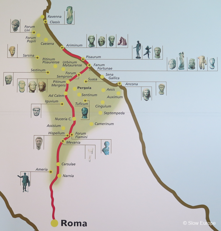
Following Ancient Roman Roads - The Via Flaminia ran from Rome north to the Adriatic coast. Several parts remain visible.
"All roads lead to Rome" was true 2,000 years ago because Rome was the center of the western world and the Romans were road builders. It is true today, at least in Italy, because the modern roads follow the same route as the ancient roads.
The Romans built roads from Rome out to their territories. Via Flaminia ran from Rome north through what is now Lazio, Umbria and Le Marche, to the Adriatic coast at Fano and then along the coast to Rimini (Emilia-Romagna) where they had a port.
The road was constructed by Gaius Flaminius (Consul of the Roman Republic) in the 2nd century BC but was repaired and upgraded during the next few centuries. Augustus, who ruled from 27BC to 14AD, restored the road and rebuilt many of the bridges. Vespasian, who ruled from 69 to 79AD, constructed the second tunnel at Furlo Gorge. Trajan, who ruled from 98AD to 117AD, repaired several bridges. The original road passed through Carsulae in Umbria but at some point an eastern route through Spoleto was added.
The total distance of the road was 210 Roman miles (311km) by the older road (the western branch through Carsulae) and 222 Roman miles (329km) by the newer road (the eastern branch through Spoleto).
The modern SS3 highway follows most of the route of Via Flaminia. Many parts of Via Flaminia remain today - some stretches of original road, bridges and remains of towns along the route. We love to hunt out these bits of ancient Rome. Below is my list of Via Flaminia sites. Some we have visited, some we have not.
Many parts of Via Flaminia remain today - some stretches of original road, bridges and remains of towns along the route.
* Denotes the sites we visited. I have included more notes and photos for these sites.
Lazio
Rome, Porta del Popolo: Via Flaminia started in Rome at the Porta del Popolo (previously called Porta Flaminia), a gate in the Aurelian Walls on the Piazza del Popolo. Nothing from this original gate remains.
Rome, the Milvian Bridge (Ponte Milvio): We have not found this.
Prima Porta: Bill Thayer says there is a sign for a Roman tunnel off the SS3 near Petra Pertusa.
Malborghetto: The museum has a medieval building with a Roman arch from Via Flaminia embedded in the wall. There is a stretch of excavated road nearby. Read more from Bill Thayer.
*Rignano Flaminio: Short stretches of Via Flaminia remain in the town of Rignano Flaminio, in Lazio north of Rome. The modern road SS3 runs along the route of Via Flaminia, so most of the original Roman road is buried beneath the modern road, but in some areas the modern road goes a different route and the ancient road is visible. One section can be found south of Rignano Flaminio. Another in the center of the town is visible.
Directions: If you are driving north from Rome it is easy to take a route that lets you see this stretch of the original Via Flaminia. From the Rome ring road, exit on the SS3 in the direction of Civita Castellana. South of Rignano Flaminio, just before the crest of a hill and a bend, you see a street sign for Antica Flaminia on your left. There is room to park. The original stones are visible at the start and the end of this stretch, where it rejoins the SS3. You can walk the stretch (500 meters, .3 mile). If you miss the turnoff continue for another 500 meters on the road and you will see where Via Antica Flaminia rejoins the road on your left. There is room to park there.
In the center of Rignano Flaminio sections of the original Via Flaminia are visible beside the main road (on your right if driving north).
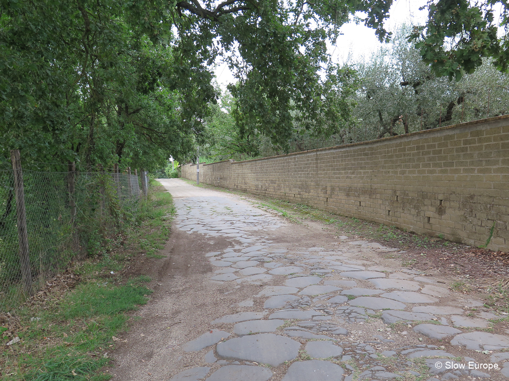
Remains of Via Flaminia in Rignano Flaminio.
Civita Castellana: A friend who lives in Civita Castellana told us there are remains of Via Flaminia near the town, but we could not find them. Via Flaminia passed east of the town.
Pile di Augusto: The Via Flaminia ran east of Civita Castellana, crossing the Tiber into Umbria over a bridge. Some vestiges can be seen. This bridge is mentioned in several places but Bill Thayer could not find it and neither could we.
Umbria
In Umbria Via Flaminia splits after Narni with an eastern and western branch before rejoining near Foligno.
*Ocriculum: The remains of a town on Via Flaminia. This is an important archaeological site and is open to the public.
*Narni Bridge of Augustus: Narni was the Roman city of Narnia. The Bridge of Augustus (Ponte d’Augusto) was built by Augustus around 27 BC in the Roman city of Narnia to carry Via Flaminia over the river Nera. It was one of the largest bridges constructed by the ancient Romans - 520 feet long (160 meters) and 98 feet high (30 meters). Of the original four arches, only one remains standing but you can see other parts of the bridge where they fell.
Directions: The remaining arch of this bridge is on the northern edge of the town of Narni. If driving heading north, keep on the SS3 going around Narni. Just before the modern bridge over the River Nera, take a right turn for Narni. Very quickly on your left you will see the a small park and the top of the arch. There is a sign for the Ponte d’Augusto. Park beside the cafe on your left and walk a short distance back to the park. There you can take steps down to the road below and to the base of the arch. From the road below, look across the river to see where other parts of the bridge have fallen.
One arch remains of this bridge on the Via Flaminia.
Umbria Western Branch
*Carsulae: The remains of a Roman town on Via Flaminia. This is an important archaeological site and is open to the public.
Acquasparta Ponte Fonnaia: Roman bridge about 4 km north of Acquasparta. Read more on Bill Thayer's Lacus Curtius.
Acquasparta Chiesa di San Giovanni de Butris: This 13th century church was built on a Roman bridge. Read more on Bill Thayer's LacusCurtius and Comune di Acquasparta.
Vicus Martis Tudertium: Archaeological site near Massa Martana. This was a town or stopping place on Via Flaminia. S. Maria in Pantano is a medieval church built in the same location, using part of an original Roman wall. Read more on Bill Thayer's LacusCurtius.
Cavallara The Devil's Bridge (Ponte del Diavolo): Bridge near Bastardo. Read more on Bill Thayer's LacusCurtius.
*Foligno Tombs: Foligno was the Roman town of Fulginium. The remains of two ancient Roman Tombs are found along the route of Via Flaminia between Bevagna and Foligno. These are small remnants of Via Flaminia, but are well worth seeking out if you are in the area. They are located at the western edge of Foligno and development is encroaching on them.
Directions: On the SS316 road from Bevagna to Foligno there are two tombs on your left. The first is at the edge of the village of Fiamenga on the corner of Via della Chiona. The second is just past the sign telling you are entering Foligno, across from the intersection of Via Santo Pietro. They are 500 meters apart. Park on either of the side streets.
Umbria Eastern Branch
*Spoleto Sanguinaro Bridge: Spoleto was the Roman town of Spoletium. The Sanguinario Bridge (Ponte Sanguinario) was on Via Flaminia where it crossed the Tessino stream on leaving Spoleto. It was still in use in the middle ages, but was eventually buried. It has been excavated and you can see it beneath the Piazza della Vittoria. Two arches of the bridge remain. The arches are not the same size, so it is thought that it was a three arch bridge, with the center arch being bigger. It was probably built in about 27BC, during the time of Augustus, when many of the bridges on the Via Flaminia were built.
Directions: The entrance to the Ponte Sanguinario is on the eastern side of Piazza della Vittoria, outside the Spoleto city walls. When we last visited it was only open in summer, Friday, Saturday and Sunday from 10:00 - 12:00 and 17:00 - 19:00. You walk down a set of stairs to a platform in front of the excavated arches.
Pontebari: Remains of a bridge.
Eastern and Western Branches of Via Flaminia Rejoin
After the branches rejoin at S. Giovanni Profiamma.
Pieve Fanonica: Bridge-like structure.
Nocera Umbra: The ancient Roman town was located below modern Nocera Umbra, in the valley, near the Topino creek. Several parts of the Via Flamina remain. Le Spugne is the name of the area (I think).
Fossato di Vico: Three bridges near this town north of Gualdo Tadino.
Villa Scirca: An imposing bridge, blown up in World War II.
Costacciaro Spiano Bridge: Ponte Spiano.
Le Marche
Sentinum: The remains of this Roman town are 1km east of modern Sassoferrato. Segments of the road have been excavated, but there might not be much to see here. Read more on Wandering Italy - Roman Roads and Livius - Sentinum.
*Pontericcioli Bridge: The Pontericcioli Bridge (Pontericcioli Ponte Tre Archi) on Via Flaminia is outside of Pontericcioli near Cantiano, close to the Umbrian border. In this area the modern road does not follow the route of Via Flaminia. Outside of Pontericcioli you first come to a small two arch bridge called Ponte Grosso (several Roman bridges in this area have the same name, which translates to Big Bridge). Further along the road is an archaeological area with the larger, three arch bridge.
Directions: The SS3 in Umbria becomes the SP3 in Le Marche. On the SP3 heading north-east direction Fano, just before the town sign for Pontericcioli, there is a left turn signed Area Archeologica on the road Via Flaminia Antica. Turn left and go down to the first river. The bridge over the river is an ancient Roman bridge. You can park and walk into the field to see it. Keep driving on that road and go uphill until the road turns sharply right. On your left you see a sign for the Archaeological Area. Park here and walk about 500 meters into the site. There is some exposed ancient road and the three arched bridge, Ponte Tre Archi.
*Cantiano Bridge: The Cantiano Bridge Ponte Grosso on Via Flaminia has two arches, crossing the River Burano. It is still in use today. There are five ancient Roman bridges on the Via Flaminia in this area. The modern SP3 highway roughly follows the route of the ancient Via Flaminia, but in many places there is a smaller road called Via Flaminia that follows the actual route.
Driving north-east on the SP3 in the direction of Fano, drive past Cantiano. About 3 km after the exit for Cantiano Nord you come to an exit marked "Ponte di epoca Romana". Take this exit, turn right and drive back parallel to the SP3 until you come to the bridge. The road you are on goes over the ancient Roman bridge.
*Cagli Mallio Bridge: Cagli was the Roman town of Cale. The Mallio Bridge (Ponte Mallio) in the town of Cagli was part of Via Flaminia. This is the oldest bridge on Via Flaminia in Le Marche and is thought to pre-date the Romans. The modern road through Cagli follows the route of Via Flaminia. A modern bridge was built beside the ancient bridge. The ancient bridge is in use today, but only for local traffic.
Directions: Heading north-east on the SP3 in the direction of Fano, take the first exit for Cagli. Keep on the SP424, called Via Flaminia, through town. The historic center is up the hill on your left. Go straight through an intersection with a bridge on your right. At the next roundabout with a petrol station and other services, where the historic center ends, go straight through onto a modern bridge. The ancient bridge is on your left, almost below the modern bridge. At the end of the bridge, turn left into a small road, then immediately left onto a track that goes onto the ancient bridge. You can leave the car here and explore the bridge. Or park back at the services area off the roundabout and walk across the modern bridge where you get a good view down to the bridge.
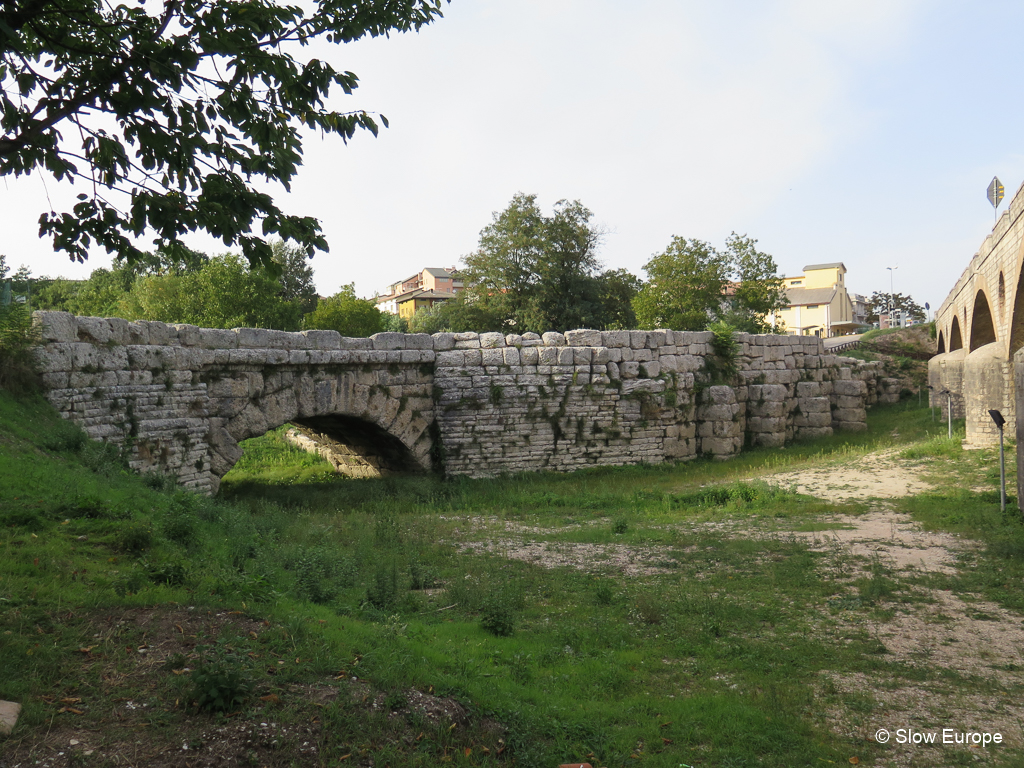
This is the oldest bridge on Via Flaminia in Le Marche and is thought to pre-date the Romans.
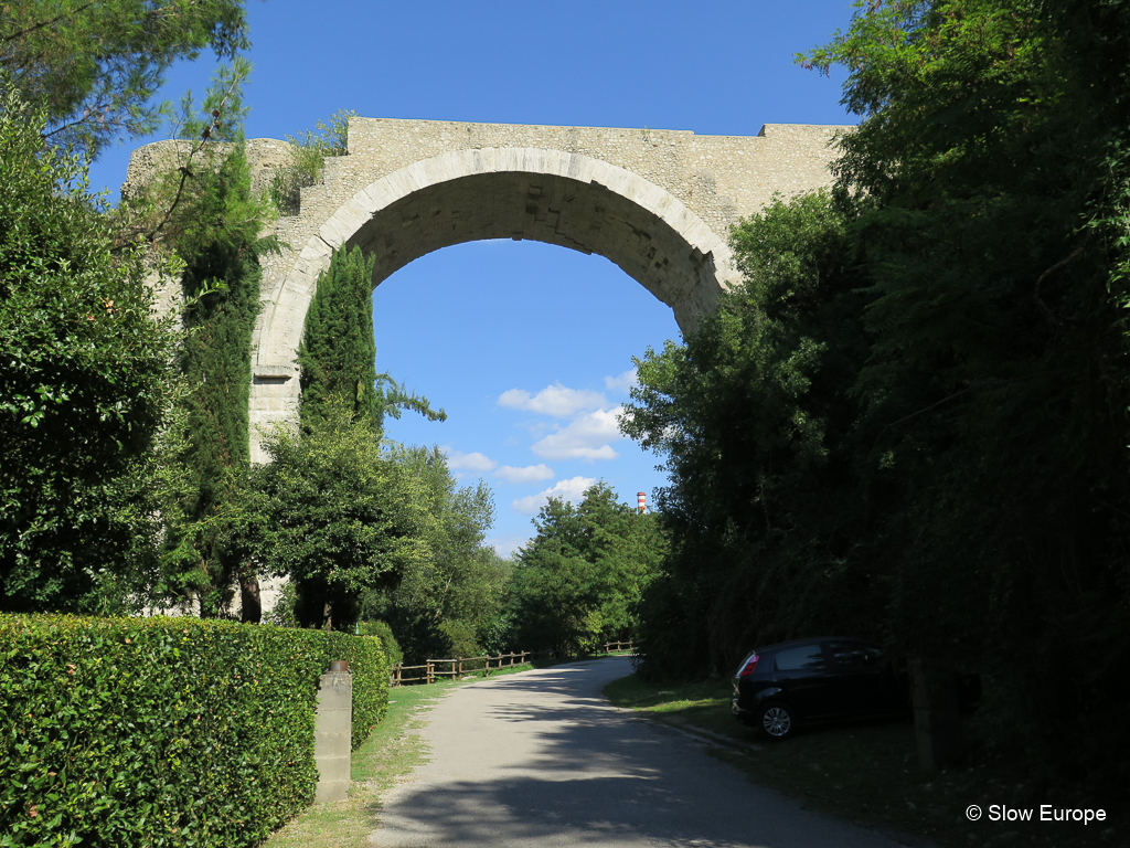
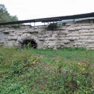
*Acqualagna Viaduct: Along Via Flaminia, between Acqualanga and Furlo, there is a small bit of excavated aqueduct. This protected Via Flaminia from being damaged when the River Candigliano flooded. It is near the San Vincenzo Abbey, a 10th century building on 6th century foundations with restored frescos inside.
Directions: The viaduct is on a side road between Acqualanga and Furlo. From the SP3 take the eastern exit for Acqualanga (also signed for Furlo and Area Archeologica), and follow signs for Furlo. When you turn left on Strada Pianacce/Via Monte Furlo in the direction of Furlo, look to your right and you will see a small sign for an Area Archeologica and a dirt lane. Park at the side of the road and walk down the lane. The viaduct is along the edge of the road, but is best viewed from below by walking along this lane. It is covered with an open roof.
Return to your car and continue a short distance down the road to Furlo and you will see the San Vincenzo Abbey (Abbazia di S. Vincenzo al Furlo) on your right. You can also park there and walk back.
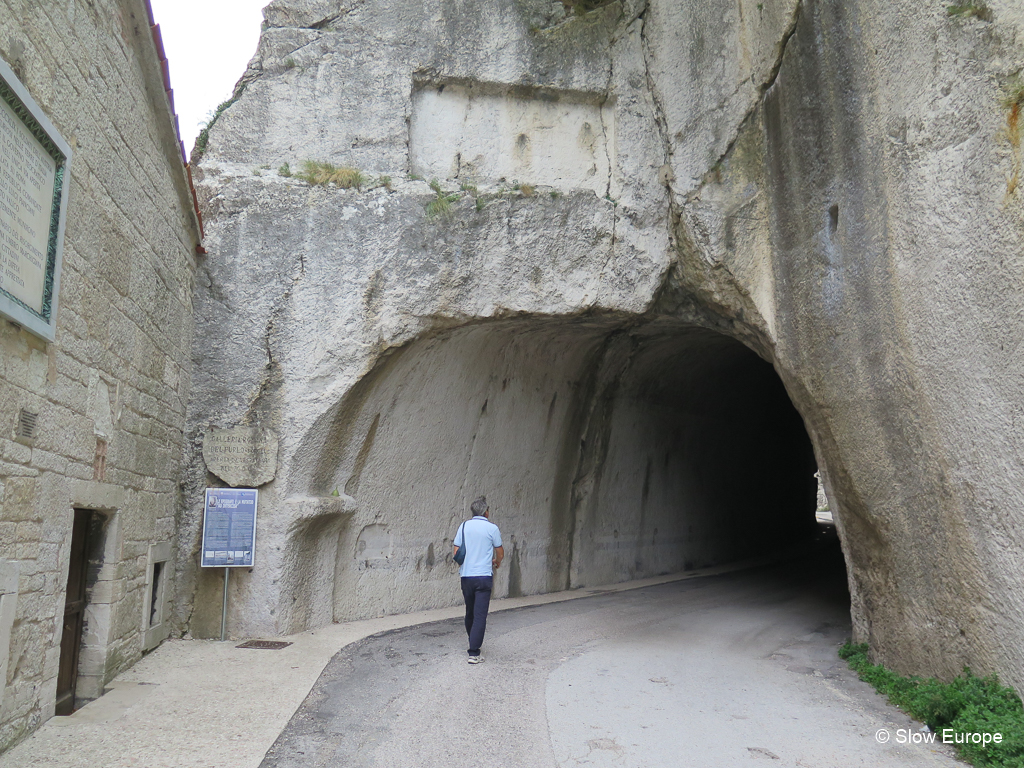
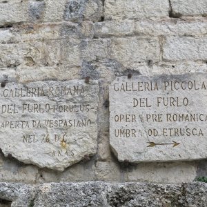
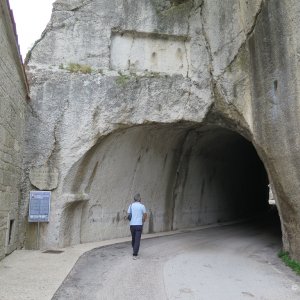
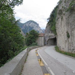
*Furlo Gorge Tunnel: The Furlo Gorge was called Intercisa, meaning cut through, in Roman times. Via Flaminia passed through the narrow Furlo Gorge (Gola del Furlo). During the original construction in 220BC the road was built into the side of the gorge and a tunnel was created. In 76AD Emperor Vespasian built a longer second tunnel. The modern road built on the original Via Flaminia uses the second tunnel today, or did until 2015 when a landslip blocked the road and traffic through the gorge was stopped. This makes it better for visitors who can now have a good look at the tunnel without cars passing by.
This stretch of Via Flaminia was difficult to construct because of the narrow gorge. There was a path beside the River Candigliano in pre-Roman times. The road was originally constructed in 220BC by cutting into the rock face. Rockslides were a problem. The original tunnel was built at this time. You can see the western entrance beside the current tunnel. The eastern entrance is covered by the small church of Santa Maria, built in 400AD.
During the Augustan period (27BC to 14AD) the road was rebuilt with supporting walls underneath. Most of these supporting walls are now underwater in the man-made lake beside the road. The second tunnel was built by Emperor Vespasian in 76-77AD. It is one of the best preserved Roman tunnels (there are less than 20 Roman tunnels in Italy). The second tunnel is 38 meters long and 6 meters high with an average width of 5.30 meters. A drainage tunnel was created at the same time.
An inscription carved on eastern entrance of the tunnel, now hidden by a wall, noted the construction of the tunnel by Emperor Vespasian 76 - 77AD. An inscription on the western entrance was added in 246AD by Aurelio Munaziano, who was in charge of monitoring the area, celebrating a victory of the Emperor Philip the Arab over local robbers. This was removed in 1886 and is in the Museum in Pesaro. When the Roman empire fell, this part of Via Flaminia was not used for trade but was frequented by bandits.
Directions: Exit the SP3 (highway to Fano) at Furlo. Follow the main road west through the village of Furlo, until it ends in the gorge. From there you can walk along the road, through the tunnel and further into the gorge.
In 76AD Emperor Vespasian built a longer second tunnel.
Calmazzo Tomb Stones: Two tomb stones in a burial ground. Nearby bridge destroyed in WWII.
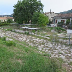
*Forum Sempronii: Forum Sempronii, near modern Fossombrone, was a Roman city founded in 2nd century BC. Via Flaminia passed through the center of the town. At one point the city occupied 35 hectares, but it was abandoned in the 5th - 6th century AD. The site is being excavated and you can see the foundations of some of the buildings and roads. A stretch of Via Flaminia is visible. This is a small archaeological site and not always open for visitors.
Directions: In Fossombrone keep on the SS3 in the direction of Fano. At the edge of town, with Via del Forno on your right, there is a small sign for the Forum Sempronii Archeaological Site on your right. Don't turn down the road but go straight and there is an entrance to a parking lot on your right.
Serrungarina Via Flaminia: Near Tavernelle, a stretch of the original road with the marks of chariot wheels still visible in the stone.
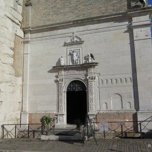
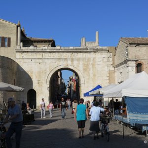
*Fano Arch of Augustus: Fano was the Roman town of Fanum Fortunae. Via Flaminia reached the Adriatic at Fano. The Roman gate to the city, the Arch of Augustus (Archo d'Augusto), remains. In 1463 the top of the gate was destroyed in a battle. The fallen fragments were used to build the adjacent church and loggia of Saint Michael. A Renaissance bass relief carved on the front of the church shows what the gate looked like originally.
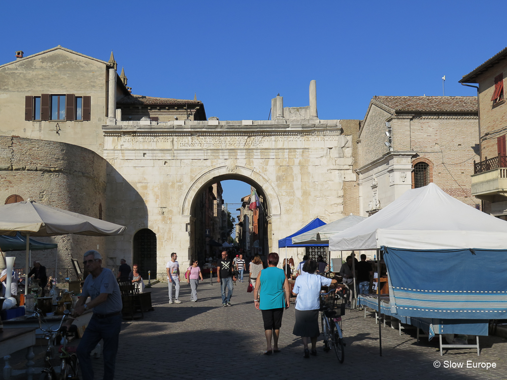
Via Flaminia reached the Adriatic at Fano. The Roman gate to the city, the Arch of Augustus (Archo d'Augusto), remains.
Pesaro Museum Oliveriano: Pesaro was the Roman town of Pisaurum. Museum in Palazzo Almerici with Roman finds.
Pesaro Ponte Vecchio: On the northern outskirts the road crossed the River Foglia at the point where the Ponte Vecchio, with its single great arch, now stands.
Emilia-Romagna
Rimini Arch of Augustus: Rimini was the Roman town of Ariminum. The Arch of Augustus (Archo d'Augusto) marks the end of Via Flaminia in Rimini. Built in 27BC it is the oldest surviving triumphal Roman arch. The top was modified in the 10th century. There are other ancient Roman remains in Rimini: original walls of the Roman city, the Tiberius Bridge built between 14 and 21AD and the ancient Roman amphitheater.
Resources
"All roads lead to Rome" was true 2,000 years ago because Rome was the center of the western world and the Romans were road builders. It is true today, at least in Italy, because the modern roads follow the same route as the ancient roads.
The Romans built roads from Rome out to their territories. Via Flaminia ran from Rome north through what is now Lazio, Umbria and Le Marche, to the Adriatic coast at Fano and then along the coast to Rimini (Emilia-Romagna) where they had a port.
The road was constructed by Gaius Flaminius (Consul of the Roman Republic) in the 2nd century BC but was repaired and upgraded during the next few centuries. Augustus, who ruled from 27BC to 14AD, restored the road and rebuilt many of the bridges. Vespasian, who ruled from 69 to 79AD, constructed the second tunnel at Furlo Gorge. Trajan, who ruled from 98AD to 117AD, repaired several bridges. The original road passed through Carsulae in Umbria but at some point an eastern route through Spoleto was added.
The total distance of the road was 210 Roman miles (311km) by the older road (the western branch through Carsulae) and 222 Roman miles (329km) by the newer road (the eastern branch through Spoleto).
The modern SS3 highway follows most of the route of Via Flaminia. Many parts of Via Flaminia remain today - some stretches of original road, bridges and remains of towns along the route. We love to hunt out these bits of ancient Rome. Below is my list of Via Flaminia sites. Some we have visited, some we have not.
Many parts of Via Flaminia remain today - some stretches of original road, bridges and remains of towns along the route.
* Denotes the sites we visited. I have included more notes and photos for these sites.
Lazio
Rome, Porta del Popolo: Via Flaminia started in Rome at the Porta del Popolo (previously called Porta Flaminia), a gate in the Aurelian Walls on the Piazza del Popolo. Nothing from this original gate remains.
Rome, the Milvian Bridge (Ponte Milvio): We have not found this.
Prima Porta: Bill Thayer says there is a sign for a Roman tunnel off the SS3 near Petra Pertusa.
Malborghetto: The museum has a medieval building with a Roman arch from Via Flaminia embedded in the wall. There is a stretch of excavated road nearby. Read more from Bill Thayer.
*Rignano Flaminio: Short stretches of Via Flaminia remain in the town of Rignano Flaminio, in Lazio north of Rome. The modern road SS3 runs along the route of Via Flaminia, so most of the original Roman road is buried beneath the modern road, but in some areas the modern road goes a different route and the ancient road is visible. One section can be found south of Rignano Flaminio. Another in the center of the town is visible.
Directions: If you are driving north from Rome it is easy to take a route that lets you see this stretch of the original Via Flaminia. From the Rome ring road, exit on the SS3 in the direction of Civita Castellana. South of Rignano Flaminio, just before the crest of a hill and a bend, you see a street sign for Antica Flaminia on your left. There is room to park. The original stones are visible at the start and the end of this stretch, where it rejoins the SS3. You can walk the stretch (500 meters, .3 mile). If you miss the turnoff continue for another 500 meters on the road and you will see where Via Antica Flaminia rejoins the road on your left. There is room to park there.
In the center of Rignano Flaminio sections of the original Via Flaminia are visible beside the main road (on your right if driving north).
Remains of Via Flaminia in Rignano Flaminio.
Civita Castellana: A friend who lives in Civita Castellana told us there are remains of Via Flaminia near the town, but we could not find them. Via Flaminia passed east of the town.
Pile di Augusto: The Via Flaminia ran east of Civita Castellana, crossing the Tiber into Umbria over a bridge. Some vestiges can be seen. This bridge is mentioned in several places but Bill Thayer could not find it and neither could we.
Umbria
In Umbria Via Flaminia splits after Narni with an eastern and western branch before rejoining near Foligno.
*Ocriculum: The remains of a town on Via Flaminia. This is an important archaeological site and is open to the public.
*Narni Bridge of Augustus: Narni was the Roman city of Narnia. The Bridge of Augustus (Ponte d’Augusto) was built by Augustus around 27 BC in the Roman city of Narnia to carry Via Flaminia over the river Nera. It was one of the largest bridges constructed by the ancient Romans - 520 feet long (160 meters) and 98 feet high (30 meters). Of the original four arches, only one remains standing but you can see other parts of the bridge where they fell.
Directions: The remaining arch of this bridge is on the northern edge of the town of Narni. If driving heading north, keep on the SS3 going around Narni. Just before the modern bridge over the River Nera, take a right turn for Narni. Very quickly on your left you will see the a small park and the top of the arch. There is a sign for the Ponte d’Augusto. Park beside the cafe on your left and walk a short distance back to the park. There you can take steps down to the road below and to the base of the arch. From the road below, look across the river to see where other parts of the bridge have fallen.
One arch remains of this bridge on the Via Flaminia.
Umbria Western Branch
*Carsulae: The remains of a Roman town on Via Flaminia. This is an important archaeological site and is open to the public.
Acquasparta Ponte Fonnaia: Roman bridge about 4 km north of Acquasparta. Read more on Bill Thayer's Lacus Curtius.
Acquasparta Chiesa di San Giovanni de Butris: This 13th century church was built on a Roman bridge. Read more on Bill Thayer's LacusCurtius and Comune di Acquasparta.
Vicus Martis Tudertium: Archaeological site near Massa Martana. This was a town or stopping place on Via Flaminia. S. Maria in Pantano is a medieval church built in the same location, using part of an original Roman wall. Read more on Bill Thayer's LacusCurtius.
Cavallara The Devil's Bridge (Ponte del Diavolo): Bridge near Bastardo. Read more on Bill Thayer's LacusCurtius.
*Foligno Tombs: Foligno was the Roman town of Fulginium. The remains of two ancient Roman Tombs are found along the route of Via Flaminia between Bevagna and Foligno. These are small remnants of Via Flaminia, but are well worth seeking out if you are in the area. They are located at the western edge of Foligno and development is encroaching on them.
Directions: On the SS316 road from Bevagna to Foligno there are two tombs on your left. The first is at the edge of the village of Fiamenga on the corner of Via della Chiona. The second is just past the sign telling you are entering Foligno, across from the intersection of Via Santo Pietro. They are 500 meters apart. Park on either of the side streets.
Umbria Eastern Branch
*Spoleto Sanguinaro Bridge: Spoleto was the Roman town of Spoletium. The Sanguinario Bridge (Ponte Sanguinario) was on Via Flaminia where it crossed the Tessino stream on leaving Spoleto. It was still in use in the middle ages, but was eventually buried. It has been excavated and you can see it beneath the Piazza della Vittoria. Two arches of the bridge remain. The arches are not the same size, so it is thought that it was a three arch bridge, with the center arch being bigger. It was probably built in about 27BC, during the time of Augustus, when many of the bridges on the Via Flaminia were built.
Directions: The entrance to the Ponte Sanguinario is on the eastern side of Piazza della Vittoria, outside the Spoleto city walls. When we last visited it was only open in summer, Friday, Saturday and Sunday from 10:00 - 12:00 and 17:00 - 19:00. You walk down a set of stairs to a platform in front of the excavated arches.
Pontebari: Remains of a bridge.
Eastern and Western Branches of Via Flaminia Rejoin
After the branches rejoin at S. Giovanni Profiamma.
Pieve Fanonica: Bridge-like structure.
Nocera Umbra: The ancient Roman town was located below modern Nocera Umbra, in the valley, near the Topino creek. Several parts of the Via Flamina remain. Le Spugne is the name of the area (I think).
Fossato di Vico: Three bridges near this town north of Gualdo Tadino.
Villa Scirca: An imposing bridge, blown up in World War II.
Costacciaro Spiano Bridge: Ponte Spiano.
Le Marche
Sentinum: The remains of this Roman town are 1km east of modern Sassoferrato. Segments of the road have been excavated, but there might not be much to see here. Read more on Wandering Italy - Roman Roads and Livius - Sentinum.
*Pontericcioli Bridge: The Pontericcioli Bridge (Pontericcioli Ponte Tre Archi) on Via Flaminia is outside of Pontericcioli near Cantiano, close to the Umbrian border. In this area the modern road does not follow the route of Via Flaminia. Outside of Pontericcioli you first come to a small two arch bridge called Ponte Grosso (several Roman bridges in this area have the same name, which translates to Big Bridge). Further along the road is an archaeological area with the larger, three arch bridge.
Directions: The SS3 in Umbria becomes the SP3 in Le Marche. On the SP3 heading north-east direction Fano, just before the town sign for Pontericcioli, there is a left turn signed Area Archeologica on the road Via Flaminia Antica. Turn left and go down to the first river. The bridge over the river is an ancient Roman bridge. You can park and walk into the field to see it. Keep driving on that road and go uphill until the road turns sharply right. On your left you see a sign for the Archaeological Area. Park here and walk about 500 meters into the site. There is some exposed ancient road and the three arched bridge, Ponte Tre Archi.
*Cantiano Bridge: The Cantiano Bridge Ponte Grosso on Via Flaminia has two arches, crossing the River Burano. It is still in use today. There are five ancient Roman bridges on the Via Flaminia in this area. The modern SP3 highway roughly follows the route of the ancient Via Flaminia, but in many places there is a smaller road called Via Flaminia that follows the actual route.
Driving north-east on the SP3 in the direction of Fano, drive past Cantiano. About 3 km after the exit for Cantiano Nord you come to an exit marked "Ponte di epoca Romana". Take this exit, turn right and drive back parallel to the SP3 until you come to the bridge. The road you are on goes over the ancient Roman bridge.
*Cagli Mallio Bridge: Cagli was the Roman town of Cale. The Mallio Bridge (Ponte Mallio) in the town of Cagli was part of Via Flaminia. This is the oldest bridge on Via Flaminia in Le Marche and is thought to pre-date the Romans. The modern road through Cagli follows the route of Via Flaminia. A modern bridge was built beside the ancient bridge. The ancient bridge is in use today, but only for local traffic.
Directions: Heading north-east on the SP3 in the direction of Fano, take the first exit for Cagli. Keep on the SP424, called Via Flaminia, through town. The historic center is up the hill on your left. Go straight through an intersection with a bridge on your right. At the next roundabout with a petrol station and other services, where the historic center ends, go straight through onto a modern bridge. The ancient bridge is on your left, almost below the modern bridge. At the end of the bridge, turn left into a small road, then immediately left onto a track that goes onto the ancient bridge. You can leave the car here and explore the bridge. Or park back at the services area off the roundabout and walk across the modern bridge where you get a good view down to the bridge.
This is the oldest bridge on Via Flaminia in Le Marche and is thought to pre-date the Romans.
*Acqualagna Viaduct: Along Via Flaminia, between Acqualanga and Furlo, there is a small bit of excavated aqueduct. This protected Via Flaminia from being damaged when the River Candigliano flooded. It is near the San Vincenzo Abbey, a 10th century building on 6th century foundations with restored frescos inside.
Directions: The viaduct is on a side road between Acqualanga and Furlo. From the SP3 take the eastern exit for Acqualanga (also signed for Furlo and Area Archeologica), and follow signs for Furlo. When you turn left on Strada Pianacce/Via Monte Furlo in the direction of Furlo, look to your right and you will see a small sign for an Area Archeologica and a dirt lane. Park at the side of the road and walk down the lane. The viaduct is along the edge of the road, but is best viewed from below by walking along this lane. It is covered with an open roof.
Return to your car and continue a short distance down the road to Furlo and you will see the San Vincenzo Abbey (Abbazia di S. Vincenzo al Furlo) on your right. You can also park there and walk back.
*Furlo Gorge Tunnel: The Furlo Gorge was called Intercisa, meaning cut through, in Roman times. Via Flaminia passed through the narrow Furlo Gorge (Gola del Furlo). During the original construction in 220BC the road was built into the side of the gorge and a tunnel was created. In 76AD Emperor Vespasian built a longer second tunnel. The modern road built on the original Via Flaminia uses the second tunnel today, or did until 2015 when a landslip blocked the road and traffic through the gorge was stopped. This makes it better for visitors who can now have a good look at the tunnel without cars passing by.
This stretch of Via Flaminia was difficult to construct because of the narrow gorge. There was a path beside the River Candigliano in pre-Roman times. The road was originally constructed in 220BC by cutting into the rock face. Rockslides were a problem. The original tunnel was built at this time. You can see the western entrance beside the current tunnel. The eastern entrance is covered by the small church of Santa Maria, built in 400AD.
During the Augustan period (27BC to 14AD) the road was rebuilt with supporting walls underneath. Most of these supporting walls are now underwater in the man-made lake beside the road. The second tunnel was built by Emperor Vespasian in 76-77AD. It is one of the best preserved Roman tunnels (there are less than 20 Roman tunnels in Italy). The second tunnel is 38 meters long and 6 meters high with an average width of 5.30 meters. A drainage tunnel was created at the same time.
An inscription carved on eastern entrance of the tunnel, now hidden by a wall, noted the construction of the tunnel by Emperor Vespasian 76 - 77AD. An inscription on the western entrance was added in 246AD by Aurelio Munaziano, who was in charge of monitoring the area, celebrating a victory of the Emperor Philip the Arab over local robbers. This was removed in 1886 and is in the Museum in Pesaro. When the Roman empire fell, this part of Via Flaminia was not used for trade but was frequented by bandits.
Directions: Exit the SP3 (highway to Fano) at Furlo. Follow the main road west through the village of Furlo, until it ends in the gorge. From there you can walk along the road, through the tunnel and further into the gorge.
In 76AD Emperor Vespasian built a longer second tunnel.
Calmazzo Tomb Stones: Two tomb stones in a burial ground. Nearby bridge destroyed in WWII.
*Forum Sempronii: Forum Sempronii, near modern Fossombrone, was a Roman city founded in 2nd century BC. Via Flaminia passed through the center of the town. At one point the city occupied 35 hectares, but it was abandoned in the 5th - 6th century AD. The site is being excavated and you can see the foundations of some of the buildings and roads. A stretch of Via Flaminia is visible. This is a small archaeological site and not always open for visitors.
Directions: In Fossombrone keep on the SS3 in the direction of Fano. At the edge of town, with Via del Forno on your right, there is a small sign for the Forum Sempronii Archeaological Site on your right. Don't turn down the road but go straight and there is an entrance to a parking lot on your right.
Serrungarina Via Flaminia: Near Tavernelle, a stretch of the original road with the marks of chariot wheels still visible in the stone.
*Fano Arch of Augustus: Fano was the Roman town of Fanum Fortunae. Via Flaminia reached the Adriatic at Fano. The Roman gate to the city, the Arch of Augustus (Archo d'Augusto), remains. In 1463 the top of the gate was destroyed in a battle. The fallen fragments were used to build the adjacent church and loggia of Saint Michael. A Renaissance bass relief carved on the front of the church shows what the gate looked like originally.
Via Flaminia reached the Adriatic at Fano. The Roman gate to the city, the Arch of Augustus (Archo d'Augusto), remains.
Pesaro Museum Oliveriano: Pesaro was the Roman town of Pisaurum. Museum in Palazzo Almerici with Roman finds.
Pesaro Ponte Vecchio: On the northern outskirts the road crossed the River Foglia at the point where the Ponte Vecchio, with its single great arch, now stands.
Emilia-Romagna
Rimini Arch of Augustus: Rimini was the Roman town of Ariminum. The Arch of Augustus (Archo d'Augusto) marks the end of Via Flaminia in Rimini. Built in 27BC it is the oldest surviving triumphal Roman arch. The top was modified in the 10th century. There are other ancient Roman remains in Rimini: original walls of the Roman city, the Tiberius Bridge built between 14 and 21AD and the ancient Roman amphitheater.
Resources
- Wikipedia - Via Flaminia
- Bill Thayer's LacusCurtius - Via Flaminia
- Antica Via Flaminia - tourism for Otricoli, Narni, Terni (map at top of article is a photo of one of their signs)
- Pesaro Urbino Tourism - Via Flaminia


Last edited: